Ozonelayer
Member
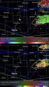
Major tornado imminent with the Illinois storm. Warm front is taking a jog NE aswell.
Follow along with the video below to see how to install our site as a web app on your home screen.
Note: This feature may not be available in some browsers.

There is also an MD for a likely watch for Oklahoma.New Tornado Watch likely for Northern IL/IN, Southern Wisconsin:
"Probability of Watch Issuance...95 percent
SUMMARY...Scattered elevated supercells and bowing segments appear
likely this afternoon/evening north of the east-west warm front. A
risk for significant hail and damaging gusts is possible. A WW is
likely needed shortly.
DISCUSSION...As of 2145 UTC, mesoanalysis and radar observations
showed an east-west oriented warm front stretching from eastern IA,
across northern IL into southern lower MI. South of the front,
temperatures in the 70s and 80s F amid mid to upper 60s F surface
dewpoints are supporting moderate to large buoyancy of 2000-3000
J/kg of MLCAPE. Strong destabilization is also ongoing in an
elevated manner along and north of the boundary with 1500-2500 J/kg
of MUCAPE despite cooler surface temperatures. Strong mid-level flow
is overspreading the boundary supporting deep veering wind profiles
supportive of organized severe storms.
Weak surface convergence southeast of the front has ignited several
supercells across northern IL this afternoon. As storms cross out of
the Tornado Watch and the front, they will become elevated. With
robust buoyancy and deep-layer shear greater than 50 kt, they are
likely to remain intense and capable of large to very large hail.
Recent CAM guidance and surface convergence near a surface low in
IA/MO suggest numerous storms will develop within the elevated
regime over the next few hours.
With time, these initial supercells are likely to grow upscale into
elevated bows or clusters with a continued hail threat and possibly
damaging winds associated with strong gravity waves propagating
along the top of the stable surface layer. Given the increasing
severe threat, a new WW is likely needed for eastern IA into
northern IL and portions of western lower MI."
Don't think that's going to be a tornado watch, no mention at all of tornadoes being they will be well north of the WF.New Tornado Watch likely for Northern IL/IN, Southern Wisconsin:
"Probability of Watch Issuance...95 percent
SUMMARY...Scattered elevated supercells and bowing segments appear
likely this afternoon/evening north of the east-west warm front. A
risk for significant hail and damaging gusts is possible. A WW is
likely needed shortly.
DISCUSSION...As of 2145 UTC, mesoanalysis and radar observations
showed an east-west oriented warm front stretching from eastern IA,
across northern IL into southern lower MI. South of the front,
temperatures in the 70s and 80s F amid mid to upper 60s F surface
dewpoints are supporting moderate to large buoyancy of 2000-3000
J/kg of MLCAPE. Strong destabilization is also ongoing in an
elevated manner along and north of the boundary with 1500-2500 J/kg
of MUCAPE despite cooler surface temperatures. Strong mid-level flow
is overspreading the boundary supporting deep veering wind profiles
supportive of organized severe storms.
Weak surface convergence southeast of the front has ignited several
supercells across northern IL this afternoon. As storms cross out of
the Tornado Watch and the front, they will become elevated. With
robust buoyancy and deep-layer shear greater than 50 kt, they are
likely to remain intense and capable of large to very large hail.
Recent CAM guidance and surface convergence near a surface low in
IA/MO suggest numerous storms will develop within the elevated
regime over the next few hours.
With time, these initial supercells are likely to grow upscale into
elevated bows or clusters with a continued hail threat and possibly
damaging winds associated with strong gravity waves propagating
along the top of the stable surface layer. Given the increasing
severe threat, a new WW is likely needed for eastern IA into
northern IL and portions of western lower MI."
Expect additional watches from NTX through OK and into KS based on some of the other recent MDs by the SPC. That is *quite* the large area with strong tornado potential (again, based on wording from the MDs) in addition to the risk in the Midwest.
Yeah I was surprised by that, but I do think there will be a watch issued for the rest of the IWX (Northern IN) region.Don't think that's going to be a tornado watch, no mention at all of tornadoes being they will be well north of the WF.
Wow, this is already too much to keep track of.Most of Oklahoma is now under a tornado watch, including OKC.
Oh 100%, the hail and wind threat is huge.Yeah I was surprised by that, but I do think there will be a watch issued for the rest of the IWX (Northern IN) region.