Ozonelayer
Member
I can't post currently, but can anybody post the 13z hrrr for posterity sake, you'll see why we probably need a upgrade lol.

Here ya go
Follow along with the video below to see how to install our site as a web app on your home screen.
Note: This feature may not be available in some browsers.
I can't post currently, but can anybody post the 13z hrrr for posterity sake, you'll see why we probably need a upgrade lol.
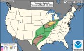
I think we may see a cig1 tornado hatch if they upgrade later.View attachment 51214
Here ya go
")

Slight was pulled more north and west as wellSPC kept Day 1 at slight.
Edit: They added a 5% tornado contour in N MS/AL


Yeah especially around meMississippi loves to make tornadoes. Just sayin’! Will be watching.
Agreed. Im actually surprised a cig1 wasn't introduced for parts of the western half of Alabama into some of Mississippi. Maybe they update it in a afternoon updateI'm worried some in Alabama are going to be taken by surprise this evening.