- Thread starter
- #81
CheeselandSkies
Member
Will you be able to chase? I know Trey said he may…
Planning on it, but I will have to work until 1 and then have work again the next day at 4 AM, so I'd rather it didn't trend any further south.
Follow along with the video below to see how to install our site as a web app on your home screen.
Note: This feature may not be available in some browsers.
Will you be able to chase? I know Trey said he may…


I simply just wouldn’t trust the NAM regarding anything having to with OWS/Dryline convection.0Z 3K NAM has the 700mb speed max timed about the same as the HRRR, but doesn't fire convection apart from elevated supercells way north of the warm front (including up into Wisconsin). I'd hazard a guess that's due to its cool bias leading to lingering capping.
However, I will say for the time of year I would like to see the mid levels be a little bit cooler than what's progged. Whatever happens, it's been a weird series of systems. Not behaving at all like typical early-mid March outbreaks where you have ample synoptic-scale forcing and very cold air aloft. Maybe in the Southeast these kind of setups have some precedent this time of year (like the Beauregard and Nashville/Cookeville days in back-to-back years), but not in the Plains/Midwest.
View attachment 51194


Good forecast thanks.Time to get my thoughts on this!
Definitely an interesting setup overall and the differences between the NAM and the CAM guidance are pretty noticeable. The NAM continues to look much more aggressive with the inversion and seems to be underdoing the boundary layer mixing, which is something it has a tendency to do in these kinds of setups. You can see it keeping a stronger warm nose in place while also holding back some of the surface thermodynamics, whereas the HRRR and most of the other CAMs mix the boundary layer more during peak heating and weaken that inversion quite a bit. If the CAMs are closer to reality, storms probably won’t have a huge issue initiating once the main forcing arrives.
The moisture return also looks fairly impressive for this time of year with mid to upper 60s dewpoints pushing pretty far north into the warm sector. With that kind of moisture combined with decent lapse rates and strong synoptic forcing from the ejecting trough, instability values getting into the 2000+ range honestly seem very easy to obtain. When you pair that kind of instability with the shear profiles that are being modeled, the environment would definitely be supportive of supercells if they can stay discrete and not congeal.
Looking at some of the recent RAP soundings across the warm sector (SE Iowa, the St. Louis area, and even down toward Wichita), the hodographs are actually pretty impressive with strong curvature in the lowest few kilometers and decent overall length. Low level shear values around 200–300 m²/s² combined with strong instability would certainly support possible tornadoes if they can take advantage of the environment. Several of those profiles also show fairly strong effective STP values and classic supercell structures, which is probably why some of the guidance keeps hinting at a very very decent setup if things come together.
That said, storm mode still seems like the biggest question with how strong the forcing is along the trough and how quickly convection may grow upscale. With the amount of large scale ascent and the strength of the mid level flow overspreading the warm sector, it wouldn’t be surprising to see storms develop fairly quickly and begin interacting with each other. If that happens early enough, the setup could transition toward more of a linear or clustered mode rather than long lived discrete supercells.
On the other hand, if a few storms can form ahead of the main forcing or along any boundaries that develop in the warm sector and remain isolated for even a short period of time, the parameter space being shown by several of the models would certainly support a potential line of supercells, based on the HRRR SO FAR. It feels like one of those setups where the environment itself looks quite favorable, but the ultimate outcome may depend heavily on how convection evolves once initiation begins.

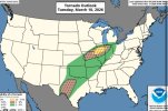
SUMMARY...
Isolated to scattered severe thunderstorms are possible on Wednesday
from the ArkLaTex and Lower Mississippi Valley northeastward through
the Ohio Valley vicinity.
...East Texas northeast to the Ohio Valley vicinity...
A split-flow regime will continue into Wednesday, with upper
troughing over the central U.S. remaining bifurcated through much of
the period. In the southern branch, a closed low/upper shortwave
trough will migrate from TX to the Lower MS Valley. Meanwhile, the
northern stream upper trough over the northern Plains/Upper Midwest
will develop east across the Upper Great Lakes/Midwest. Ahead of
these features, strong southwesterly deep-layer flow will extend
from east TX into the Mid-Atlantic/New England. At the surface, a
cold front will extend southwest from a surface low over southern
Lower MI into western OK. This front will advance southeast through
the period, becoming oriented from the Mid-Atlantic coast to the
central Gulf coast by Thursday morning.
Strong warm advection ahead of the front will transport Gulf
moisture as far north as the Mid-Atlantic and southern New England.
Ongoing convection is expected ahead of the front across portions of
the ArkLaTex into the Midwest. This, along with the warm advection
regime resulting in widespread cloudiness, lends to uncertainty in
how the downstream airmass will destabilize, especially with
northeast extent into parts of the Ohio Valley vicinity. Somewhat
stronger destabilization is likely across the Lower MS Valley where
richer Gulf moisture will reside. Strong vertical wind profiles will
support damaging wind potential with even modest instability. Linear
convection is the most likely storm mode given deep-layer flow
parallel to the surface boundary and strong large-scale ascent
overspreading the boundary. If discrete cells can form, some tornado
potential will exist closer to a deepening surface cyclone in the
vicinity of the upper Ohio Valley, and perhaps near a secondary
surface low over the lower MS Valley, though this scenario remains
highly uncertain.

I wouldn't be shocked if a few cells in Northern LA and southern MS pop up. In my unprofessional opinion, an upgrade to a 5% for both the bow echo and the cells seems like a good option.Looks like a nasty bow echo this evening in the deep south. Don't be surprised for a upgrade to enchanced ._.
Today is going to surprise a few people in the deep south I think
Does the bow echo get all the way into GA? Can't access models at work but FFC's discussion seemed to indicate that they think it'll fizzle out around the AL/GA line. I imagine it'll be a primarily LA/MS/AL event.Looks like a nasty bow echo this evening in the deep south. Don't be surprised for a upgrade to enchanced ._.
Today is going to surprise a few people in the deep south I think
Does the bow echo get all the way into GA? Can't access models at work but FFC's discussion seemed to indicate that they think it'll fizzle out around the AL/GA line. I imagine it'll be a primarily LA/MS/AL event.
Definitely in agreement with that. Hrrr is impressive with supercells and bow echoI can definitely see some surprises happening across north/central MS and AL. I think an upgrade to enhanced may be in order.