• Welcome to TalkWeather!
    We see you lurking around TalkWeather! Take the extra step and join us today to view attachments, see less ads and maybe even join the discussion.
    CLICK TO JOIN TALKWEATHER

Severe Weather 3/4 - 3/8

New day 3, Thursday by Thompson


SCATTERED SEVERE THUNDERSTORMS ARE EXPECTED THURSDAY AFTERNOON AND
INTO THURSDAY NIGHT FROM WEST TEXAS INTO KANSAS. LARGE HAIL APPEARS
TO BE THE MAIN THREAT, THOUGH A COUPLE OF TORNADOES AND ISOLATED
SEVERE GUSTS WILL ALSO BE POSSIBLE.

..SOUTHERN/CENTRAL PLAINS THURSDAY AFTERNOON/NIGHT


AMPLIFICATION OF A MIDLEVEL TROUGH IS EXPECTED NEAR THE FOUR CORNERS
THURSDAY INTO THURSDAY NIGHT, AS A DOWNSTREAM LEE CYCLONE DEEPENS
ACROSS EASTERN CO. THE DEEPENING CYCLONE WILL DRAW MOISTURE
NORTHWARD FROM TX ACROSS THE SOUTHERN/CENTRAL PLAINS THROUGH EARLY
FRIDAY IN THE DEVELOPING WARM SECTOR. THE LEE TROUGH/DRYLINE WILL
BE LOCATED NEAR OR JUST WEST OF THE KS/CO AND TX/NM BORDERS BY LATE
AFTERNOON AS THE CYCLONE DEEPENS IN PLACE. SURFACE HEATING IN CLOUD
BREAKS COULD ALLOW SUFFICIENT VERTICAL MIXING TO WEAKEN CONVECTIVE
INHIBITION AND ALLOW ISOLATED THUNDERSTORM DEVELOPMENT ALONG AND
JUST EAST OF THE DRYLINE BY LATE AFTERNOON ACROSS THE TX
PANHANDLE/SOUTH PLAINS INTO SOUTHWEST KS. THE STORM ENVIRONMENT
WILL CONDITIONALLY FAVOR SUPERCELLS CAPABLE OF PRODUCING LARGE HAIL
NEAR OR JUST IN EXCESS OF 2 INCHES IN DIAMETER. THE TORNADO THREAT
WILL BE A LITTLE GREATER BY EARLY EVENING AS LOW-LEVEL SHEAR
INCREASES AND NEAR 60 F DEWPOINTS SURGE NORTHWARD FROM OK INTO KS,
THOUGH THE TORNADO THREAT WILL DEPEND ON A SUPERCELL OR TWO
PERSISTING INTO LATE EVENING.

OTHERWISE, ELEVATED CONVECTION WILL SPREAD NORTHEASTWARD THURSDAY
NIGHT AS THE LOW-LEVEL JET AND ASSOCIATED WARM/MOIST ADVECTION
INCREASE. STEEP MIDLEVEL LAPSE RATES WILL SUPPORT THE POTENTIAL FOR
LARGE HAIL WITH THE OVERNIGHT CONVECTION AS FAR NORTH AS NE/IA.

..THOMPSON.. 03/03/2026


I see the Twitter weenies are back to dooming n' glooming about things on the Plains. Still plenty of signs for activity out there and plenty of time for things to change for better or worse.
1772567088978.png1772567093880.png1772567100447.png1772567105397.png1772567203397.png1772567212432.png1772567253929.png1772567257648.png
 
Ok so why isn’t this on SPc? The hatching I see here on X.
There's going to be ups and downs because this is something that is still being implemented. From here, since the SPC outlook itself is being buggy:
1772568789864.png
 
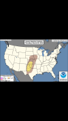
Broyles is the GOAT now. This slander must end.

Don't get me wrong, he's very knowledgeable but I do maintain he has a distinct bullish bias for severe/particularly tornado potential (4/2/25 aside). Might be just a philosophical difference, as well. He tends to forecast for the "worst case scenario" whereas some other SPC forecasters lean toward the "most likely scenario" (which is the approach the chaser in me prefers to see).
 
hey, Chicagoland resident here, saw that we're under 15 percent severe, been looking at gfs models as well, looked at a 12z sounding, it read marginal tor. any thoughts/opinions about it for me?

The parameter space looks to hold at least some severe potential Friday evening (northern Illinois would be my target if I were to chase). The main question I have right now is, what would be our initiating mechanisms with the main upper-level jet streak and surface boundaries lagging well back to the west?
 
Back
Top