• Welcome to TalkWeather!
    We see you lurking around TalkWeather! Take the extra step and join us today to view attachments, see less ads and maybe even join the discussion.
    CLICK TO JOIN TALKWEATHER

Severe Weather 3/15 - 3/16

Monday is definitely one of those events that STP underestimates because it has (IMO) a CAPE bias. Ignore the LCL and CIN components here, since most MDT+ risks already cover them pretty well. EBWD is a measure of bulk shear.

For example, Monday has 300 ESRH and 60 EBWD widespread, although CAPE is in the low 1000s. However, this would rate about the same as a setup with 4500 ML, 100 ESRH, and 30 EBWD. In my experience, the first setup performs much better than the second. i.e., the big time SRH events with just adequate CAPE are usually much more dangerous than the CAPE bomb with low-moderate shear.

View attachment 51820
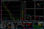
its to note that the ML LCL stops getting higher at 1000 m for STP , but studies on long track tornado has 700 m being the cap zone , after 1534 in MLCAPE it doesn't seem to help to boost it out for long track tornadoes , there is a specific long track tornado parameter made with these rules in mind

in thermodynamic wise for a long track tornado its already maxed out if its
MLCAPE :1534+
MLLCL : 200-700 Meters
MLCIN : -2 to -50

there are other important things for long track tornadoes in the Kinematic however every single one of the most important ones are somehow not on SHARPY , thus you can not see them.
 
This has been one o m best forecasts in a long while.

Multiple of us has noted SE AL as a area to watch for sigtors an therefore the SPC has outlined it. I got one more to watch.

NW AL on the 06z HRRR has caught my eye due t a limited window for prefrontals and potentially a few tornadoes if stratiform/crapvection doesn't limit instability up here.

SE AL of course continues to be noted. And Monday continues to look like a dangerous, high impact event as I've advised this whole time with many others. Heed it seriously. I expect a potential CIG2 upgrade with thi, the environment is VOLATILE.
 
I still think the ENH needs to be expanded a bit more to the south and west tomorrow. I pulled this from somewhere around Telfair County, GA at 18z tomorrow, i.e. at the very fringes of the ENH and it's still popping PDS TORs. Maybe slightly contaminated but that's still a volatile environment.
 

Attachments

  • nam_2026031506_036_31.93--82.76.png
    nam_2026031506_036_31.93--82.76.png
    255.2 KB · Views: 0
From everything I’m seeing, there’s a solid chance that we get a HIGH for tomorrow at some point or another. Very worried about the 3CAPE paired with those volatile shear profiles and the possibility of prefrontal supercells. The way the trough is modeled for tomorrow’s threat is just filthy.
 
From everything I’m seeing, there’s a solid chance that we get a HIGH for tomorrow at some point or another. Very worried about the 3CAPE paired with those volatile shear profiles and the possibility of prefrontal supercells. The way the trough is modeled for tomorrow’s threat is just filthy.
I actually think it’s very likely we see a HIGH tomorrow. That trough modeled is really disgusting and the fact that they alone went with a day 2 moderate kinda paints the picture.
 
We are in Georgia visiting family (Warner Robins area). Who’s the best meteorologist for keeping up with the weather here? I’m lucky enough to have Matt Laubhan and James Spann (live just across the state line) at home, but I’m clueless out here.
I grew up there and generally watched WMAZ.
 

I mean, if it’s even 50-60% of the CAPE currently being shown on that graphic, that’s still a violate parameter space for March. With strong kinematics, you don’t need a ton of CAPE always.

I think if there is a true fail mode, it won’t be readily apparent until tomorrow morning. I do like his statement on possible crapvection because the absence of a cap, but we’ll have to see in real time.
 
So I guess I'm a little bit surprised they pulled back the 10% TOR risk, but I can see why with capping issues. I'm also a little surprised that a Moderate driven damaging wind upgrade hasn't happened.
 
I genuinely think there is a good chance we see a HIGH risk tomorrow.

ANY Prefrontals will have the potential for strong to intense, long tracked tornadoes and I really dont think a violent tornado or two is out of the picture. Trends will have to keep up painting this picture. Next D2 should be reqlly interesting if this continues.
 
Back
Top