KakashiHatake2000
Member
Hope the both of you stay safe yall will get through it everybody will
Follow along with the video below to see how to install our site as a web app on your home screen.
Note: This feature may not be available in some browsers.

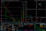
would definitely need a southward expansion of the risk area on Monday into Georgia based on that run, the forecast soundings down there look pretty spicy. I pulled this one from right around KJGX.12z NAM was an outbreak of severe storms across the SE and Mid Atlantic states Sunday night through Monday. Alarmingly large area of favorable parameter space.
I hope you stay safe my friend, and I’m keeping a close eye on this setupSoooo haven’t looked at any models yet even tho I should. lol. But best place to chase for this event around my region? I’m in Lynchburg with @Atlantic
Gonna be for chasing for sure might drop south and setup around Greenville NC, we’ll see as models go back and forth.I hope you stay safe my friend, and I’m keeping a close eye on this setup
Any possibility of tornadoes you think? I feel like we will definitely see some kind of severe weather.Gonna be for chasing for sure might drop south and setup around Greenville NC, we’ll see as models go back and forth.
Stay safe as well, we’ve got a high-end setup becoming more and more favorable for us.
Definitely could have legit hogs in the Carolinas. At this point looks more like just wind NE of virginia beach or soAny possibility of tornadoes you think? I feel like we will definitely see some kind of severe weather.
What are we seeing high-end wise?
Yep VA, at least our area is gonna be an absolute wind bag. The further east you go the worse it’ll get in terms of supercells. The more backing of the winds we have, the more trouble we might have.Definitely could have legit hogs in the Carolinas. At this point looks more like just wind NE of virginia beach or so


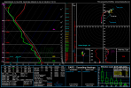
Yep. I know people are highlighting the QLCS/damaging wind risk for Sunday, but overnight in MS/AL/GA, I think the tornado risk is very legit.12z NAM suggests conditional potential for confluence bands middle of the night in MS/AL. It's not often a event starts at 2am in the morning and will likely be nonstop progressive with tor warnings throughout the day only going on to the even more impressive parameter space later in the Carolinas. If confluence band attempts mature, significant tornado threat would be highly increased.
Oh, i agree. It may be sporadic development but I'd eye central al and southern portions of the state where mid level temps aren't as warm and that will be enough WAA advection to get going some confluence bands. It all depends on if they can mature something. Those confluence bands could also set the stage for areas like Georgia going into the afternoon, with sigtor risk. Widespread large area of concerning parameter space with nonstop WAA leading to confluence bands throughout the morning to persist into higher instability sounds like a major problem to me.Yep. I know people are highlighting the QLCS/damaging wind risk for Sunday, but overnight in MS/AL/GA, I think the tornado risk is very legit.
completely agree. not gonna have the same "just in time" moisture issue as the sunday risk in the mid-south/OH valley.Yep. I know people are highlighting the QLCS/damaging wind risk for Sunday, but overnight in MS/AL/GA, I think the tornado risk is very legit.