

Navigation
Install the app
How to install the app on iOS
Follow along with the video below to see how to install our site as a web app on your home screen.
Note: This feature may not be available in some browsers.
More options
-
Welcome to TalkWeather! We see you lurking around TalkWeather! Take the extra step and join us today to view attachments, see less ads and maybe even join the discussion. CLICK TO JOIN TALKWEATHER
You are using an out of date browser. It may not display this or other websites correctly.
You should upgrade or use an alternative browser.
You should upgrade or use an alternative browser.
Severe Weather 2026
- Thread starter KevinH
- Start date

jackhutwx
Member
2nd season incoming i guess. i have been noticing some things lining up for a couple of severe days from the end of october going into november. def something to keep an eye out for.
tennessee storm chaser
Member
- Messages
- 1,916
- Reaction score
- 4,396
- Location
- jackson tennessee
- Special Affiliations
- SKYWARN® Volunteer
Illinois again lol who would guess it2nd season incoming i guess. i have been noticing some things lining up for a couple of severe days from the end of october going into november. def something to keep an eye out for.

I would be cautious still of how much or big of the severe weather threat. With southern jet playing a key role going forward, these systems might be too fast to really tap into moisture return plus I get the feeling we might end up with more heavy rainfall/flash flood events than robust outbreaks more inland.

Kds86z
Member



CheeselandSkies
Member
I would be cautious still of how much or big of the severe weather threat. With southern jet playing a key role going forward, these systems might be too fast to really tap into moisture return plus I get the feeling we might end up with more heavy rainfall/flash flood events than robust outbreaks more inland.
Yup. Already devolved into split-flow slop that wraps up into a cut-off bowling ball on the current GFS run. Any coherent trough ejection keeps getting pushed further out in time and then downtrending as it gets closer. Been doing this for like six weeks now. At one point the system that recently caused the several-day stretch of severe weather over the Southwest looked like it might eject east and do the same over the Plains/Midwest. Not so much.
CheeselandSkies
Member
06Z looks a little better than 00Z, but it's going to be one of those setups that comes down to how well the two jets phase and predicting that is always a crapshoot at this range.

It seems like all of those wind events near the chicago metro added up...
Kds86z
Member

Cyclonic Paracosm
Member
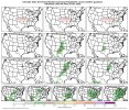
yeah its popping up now p consistently

WeathermanLeprechaun
Member
Context: this is a lesser known machine learning guidance used by CSU. it's strictly experimental, but in my experience it has performed quite impressive in multiple days. Probabilities are still on the low end for significant svr however, indicating discrepanciesView attachment 55400
yeah its popping up now p consistently
- Moderator
- #2,953

This morning Spann started mentioning a possible severe threat for Alabama next week. First Birmingham met to mention severe.
"PATTERN CHANGE: The long dry spell will end across Alabama this weekend; highest coverage of rain is expected Sunday.
A more dynamic system is due in here by the middle of next week... this might even offer the potential for strong to severe thunderstorms. Too early to be specific; simply something to watch for now.
Alabama's tornado season begins Sunday... it runs from November through May."
From SPC this morning for next week:
Medium-range forecast guidance suggests a deepening upper cyclone
and attendant trough will emerge from the western U.S. into the
Plains and Mid/Lower MS Valley vicinity Days 7-8/Monday-Tuesday.
Increasing southerly low-level flow via deepening surface
cyclogenesis will foster northward transport of rich Gulf moisture
ahead of an eastward-advancing cold front. Despite increasing
moisture, current forecast guidance maintains only modest
instability due to weak lapse rates and possible inhibition around
850-700 mb. This general pattern could support severe thunderstorms
depending on the evolution of the warm sector. However, uncertainty
is high due to large spread among forecast guidance in the placement
and timing of the upper trough. Trends will be monitored for
increasing severe potential across the south-central U.S. early next
week.
KakashiHatake2000
Member
Here it is right here
Still way too much inter-model and run-to-run variability to do much more than watch with distant interest, but we are getting into that time of the year. Still plenty of time for it to trend towards being a Gulf Coast scraper that would give us a cold rain and not much else, and would want to see more agreement on the large-scale details.
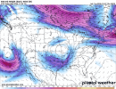

What a absolute chonker of a bowling ball at 500mb on the GFS for early next week.
Once spc outlines I'll pop a thread for this one, it has some potential.
WeathermanLeprechaun
Member
They have noted high discrepancy here so potential is uncertain atm. Wouldn't be surprised if they don't honestly but guidance should rearrange soonOnce spc outlines I'll pop a thread for this one, it has some potential.
KakashiHatake2000
Member
current look between gfs and euro model out puts
Hey don't be a party pooper leprechaun, I need a reason so I can get back on the forum. And get out of the talkweather slumber I've been in from the quiet season lol. Lol hopefully we will know something better in about 2-3 daysThey have noted high discrepancy here so potential is uncertain atm. Wouldn't be surprised if they don't honestly but guidance should rearrange soon