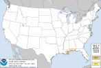
new day 5 slight
...DISCUSSION...
A surface high will move from the OH Valley into the Northeast on
Fri/D4 as an upper trough lifts out of the region and temporary
upper ridging occurs. A stationary boundary is still forecast to be
along the northern Gulf Coast at this time, and a weak midlevel wave
will begin to form over TX. Meanwhile, a potential tropical cyclone
may develop toward the central Gulf of America.
Low-level winds will begin to veer to a southeasterly direction
along the Gulf Coast late Fri/D4 into Sat/D5, as the potential
tropical cyclone evolves. NHC currently gives a high probability of
this occurring. As such, an influx of rich moisture will develop out
of the south, with a substantial rain shield and embedded
thunderstorms likely along the northern Gulf Coast beginning Fri/D4
night. Initially, surface temperatures over land will remain cool
due to precipitation and initial modification of the surface ridge
air mass.
At this time, it appears Sat/D5 is the most likely time for the more
substantial low-level warming to occur, with tropical yet
sufficiently unstable profiles. Of particular note is how the
developing shortwave trough over TX interacts with the tropical low.
Some models indicate 40-45 kt midlevel winds, which would complement
the strong low-level shear and favor low-topped supercells with
tornado potential. The greatest threat area should be along the
coastal counties given expected poor low-level lapse rates farther
inland. Initial elevated convection may give way to an east-west
zone of supercells as the coastal baroclinic zone moves inland. Some
additional threat into Sun/D6 may exist as well.
For the period Mon/D7 into Tue/D8, models are now developing an
amplified upper trough over the western CONUS. Low-level moistening
will be most prominent later in the period, and could eventually
result in a zone of strong to severe storm potential, however,
predictability is quite low at this time.