

CheeselandSkies
Member
Trey on the case:
Follow along with the video below to see how to install our site as a web app on your home screen.
Note: This feature may not be available in some browsers.


That was a potentially EF3+ intensity tornado in Utah. @N0mz I'm calling you because orographic influence absolutely had something to do with this one.
Just to put this into perspective, this is likely the first time a 80+ kt VROT couplet has been recorded this far West in the US and was also likely a major tornado. Utah hasn't seen a tornado like this intensity wise since potentially 1993. Wow.
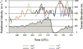
Supercell tornadogenesis coming down the lee side of a mountain is textbook orographic influence. See this figure from
Bosart et al. 2006, where vrot quickly increases on the Great Barrington 1995 supercell after coming down the lee side of a mountain. The quickly dropping elevation forces the mesocyclone to stretch vertically, constricting the diameter of the mesocyclone. Due to the conservation of angular momentum, this increases the rotational velocity, much like a figure skater pulling their arms in.
View attachment 55015
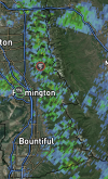
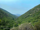
Another orographic note: I noticed this persistent area of reflectivity on radar in the area, unrelated to precipitation or any gust front. I assume this is valley channeling caused by Farmington Canyon, which shows up on radar since bugs and other particles get stuck in the valley. Valley channeling, especially in north-south oriented valleys, can locally increase moisture and vorticity by literally channeling air mass up the valley, allowing a relatively tame supercell to produce a damaging tornado.
View attachment 55016View attachment 55018
I recommend watching June First's video on the Great Barrington tornado, which explains both of the above orographic phenomena with good visuals.
Yeah possibly Bennett's Valley?I think this is interaction also happened with 1985 Moshannon multiple times. That one has a super interesting damage path.


likely photogenic tornado migth be about to form

Been textbook thus far . Go from monsoon early summer rains to extreme drought n heat now . Going be interesting to see how cool severe weather season plays particularly areas of Midsouth and Dixie .with this super Nino unfolding .On a scale of 1-10, the uniqueness of this year's weather in my area has been a 10. I've never felt heat and humidity like we had a for a few weeks there, and I've never experienced rain like we've had the last two weeks. I think the sun has been out for maybe 6 hours total. I have seedlings in trays that are dying from root rot because the soil won't dry. It just will not stop raining/misting. It's relentless. I hope it doesn't start affecting the crops. I definitely don't think harvest is going to happen anytime soon.
Anyone else experiencing unique weather this year? 1-10? They say warming oceans and super El Ninos lead to more weather extremes, and I gotta say, this El Nino has performed exactly as advertised so far.

