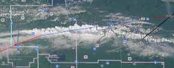
New Brunswick and Quebec look downright scary tomorrow. If (and this is a big if) any lone supercells form in that environment I would not even rule out a violent tornado. I saw soundings last night where the analog supercells in Quebec were the Andover tornado of 1991 and ones in New Brunswick which were the Topeka, Kansas 1966 event. Yikes!
Navigation
Install the app
How to install the app on iOS
Follow along with the video below to see how to install our site as a web app on your home screen.
Note: This feature may not be available in some browsers.
More options
-
Welcome to TalkWeather! We see you lurking around TalkWeather! Take the extra step and join us today to view attachments, see less ads and maybe even join the discussion. CLICK TO JOIN TALKWEATHER
You are using an out of date browser. It may not display this or other websites correctly.
You should upgrade or use an alternative browser.
You should upgrade or use an alternative browser.
Severe Weather 2026
- Thread starter KevinH
- Start date

WeathermanLeprechaun
Member
It's the NAM. It always overplays tornado threats. Never Accurate Model as many call it. the tornado threat isn't that high otherwise I'm absolutely sure the SPC would've been introducing a 10 or higher hatched by now. Environment Canada do a poor job at messaging severe weather threats admittedly.Regarding the New England threat I saw a model run last night of the NAM which had the outbreak showing as a bunch of discrete or semi-discrete supercells in Quebec and New Brunswick with the hodographs having PDS tornado as most likely risk in Quebec and tornadoes as most likely risk in NB. I think there is still a chance for some nasty tornadoes up in Eastern Canada tomorrow. I am very puzzled by Environment Canada's seeming underplaying of the threat on the significant weather outlook... compared to the SPC?
WeathermanLeprechaun
Member
Also, the latest trends on the tree eating tornadoes in NW Quebec is that low level shear downtrended some and there a lot of ifs with it. Conditional strong tornado threat now but low level hodographs not as inflated due to downtrends of the mid level jet in particular.
Also tomorrow will feature more of a prominent large hail threat than tornadoes. While low level shear occasionally becomes significant, I'm not expecting strong/violent tornadoes at all tomorrow. But it is still a impressive parameter space given the region in question. A couple tornadoes, large hail and isolated damaging winds when storms eventually cluster are possible.
Also tomorrow will feature more of a prominent large hail threat than tornadoes. While low level shear occasionally becomes significant, I'm not expecting strong/violent tornadoes at all tomorrow. But it is still a impressive parameter space given the region in question. A couple tornadoes, large hail and isolated damaging winds when storms eventually cluster are possible.

joshoctober16
Member
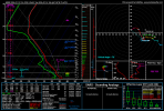
HRRR in quebec.
and yeah canada is doing a poor job with warning tornadoes in eastern canada.
SamB01
Member
This is a sounding for tomorrow 7pm EDT taken roughly over my house, +/- a mile or two. I think that's the most potent environment we've had here in the last ... few years for sure?
It's still just the NAM, and that sounding alone doesn't make it a slam dunk (by this region's standards), but I'm also surprised by the lack of discussion from Environment Canada / Weather Network / others about the potential here. Maybe they don't buy it.
In any case this setup is probably my best shot at actually chasing something for once as opposed to following online from afar!
It's still just the NAM, and that sounding alone doesn't make it a slam dunk (by this region's standards), but I'm also surprised by the lack of discussion from Environment Canada / Weather Network / others about the potential here. Maybe they don't buy it.
In any case this setup is probably my best shot at actually chasing something for once as opposed to following online from afar!
Attachments
![soundings-[45.38,-72.1]-nam4km-stp-ca_e-2026071312-35.png](https://attachments.talkweather.com/data/attachments/54/54883-daac368d079bdfe8889c465a74522a3e.jpg?hash=MSIdtALcMq)
joshoctober16
Member
is this usa or canada? what state is this?This is a sounding for tomorrow 7pm EDT taken roughly over my house, +/- a mile or two. I think that's the most potent environment we've had here in the last ... few years for sure?
It's still just the NAM, and that sounding alone doesn't make it a slam dunk (by this region's standards), but I'm also surprised by the lack of discussion from Environment Canada / Weather Network / others about the potential here. Maybe they don't buy it.
In any case this setup is probably my best shot at actually chasing something for once as opposed to following online from afar!

KakashiHatake2000
Member
Looks to be in Quebec Canada upon entering the coordinates
SamB01
Member
This is just west of Sherbrooke, QC, Canadais this usa or canada? what state is this?
joshoctober16
Member
the fires in ontario migth mess up the risk
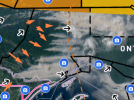
joshoctober16
Member
pyro storms are forming rigth now , im pretty sure its also the area were storms were expected.
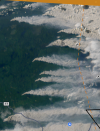
akt1985
Member
This might play into the severe risk tomorrow, but much of New England is under a Heat Advisory right now.
Nadocast pretty much lining up with where I've been saying likely highest risk is going to be. I think most of the tornado action will be in Canada rather than the US tomorrow. http://data.nadocast.com/202607/202...models_conus_tornado_20260713_t12z_f24-47.png
akt1985
Member
Since tomorrow’s risk will affect an area that normally doesn’t get severe weather, should a thread be started?

Kds86z
Member
FEW SEVERE GUSTS ABOVE 70 MPH MAY OCCUR. THE POTENTIAL
FOR LARGE HAIL AND TORNADOES WILL BE MOST LIKELY WITH SUPERCELLS.
THE THREAT FOR SUPERCELLS WILL BE GREATEST FROM NORTHERN NEW YORK
INTO NORTHERN VERMONT AND NORTHWEST MAINE, WHERE MID-LEVEL LAPSE
RATES ARE FORECAST TO BE NEAR 7 C/KM. WITHIN THIS CORRIDOR, 0-3 KM
STORM-RELATIVE HELICITY IS FORECAST TO BE IN THE 250 TO 300 M2/S2
RANGE, SUGGESTING POTENTIAL FOR A STRONG TORNADO.
FOR LARGE HAIL AND TORNADOES WILL BE MOST LIKELY WITH SUPERCELLS.
THE THREAT FOR SUPERCELLS WILL BE GREATEST FROM NORTHERN NEW YORK
INTO NORTHERN VERMONT AND NORTHWEST MAINE, WHERE MID-LEVEL LAPSE
RATES ARE FORECAST TO BE NEAR 7 C/KM. WITHIN THIS CORRIDOR, 0-3 KM
STORM-RELATIVE HELICITY IS FORECAST TO BE IN THE 250 TO 300 M2/S2
RANGE, SUGGESTING POTENTIAL FOR A STRONG TORNADO.
akt1985
Member
This morning’s risk area is still the same north of I-90.
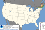
SPC has upgrade to a 10% hatched for parts of Maine for tornado but I still think the most lilkely area for tornadoes will be the Eastern Townships in QC. I'm guessing a thread might be required. Good news is I think the tornado risk for NB has downtrended a little. However, the bad news is that while the 10% hatched only impacts about 40k people in the United States the Canadian side likely is impacting up to 2 million people and is touching the northern parts of Montreal which is a metro of over 4 million. Any strong tornadoes that do develop today especially on the Canadian side could be a major threat to life and property.
SamB01
Member
Last few HRRR runs seem much less bullish than it was last night already. Plus it's still completely overcast here. The little bit of sun I see poke through looks very red, I'm wondering if it's the smoke from the fires throwing a wrench in things
This is a great question. We will have to see how today unfolds at this point. But the potential is still there. But there are some clear failure modes here of which the smoke from the wildfires in Western Quebec could play a part.Last few HRRR runs seem much less bullish than it was last night already. Plus it's still completely overcast here. The little bit of sun I see poke through looks very red, I'm wondering if it's the smoke from the fires throwing a wrench in things
SamB01
Member
Definitely. I still put the word out to family and friends to pay a special attention to the weather today, since this is not something people around here are used to
joshoctober16
Member
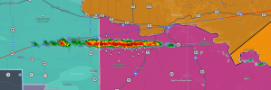
this strange storm that grew so fast is oddly straight to the point i thought it was a glitch but isn't , a lot of lightning with it.