Navigation
Install the app
How to install the app on iOS
Follow along with the video below to see how to install our site as a web app on your home screen.
Note: This feature may not be available in some browsers.
More options
-
Welcome to TalkWeather! We see you lurking around TalkWeather! Take the extra step and join us today to view attachments, see less ads and maybe even join the discussion. CLICK TO JOIN TALKWEATHER
You are using an out of date browser. It may not display this or other websites correctly.
You should upgrade or use an alternative browser.
You should upgrade or use an alternative browser.
Severe Weather 2026
- Thread starter KevinH
- Start date
WeathermanLeprechaun
Member
Musings about this svr sequence as it continues
tmrw will focus around the Iowa/Nebraska vicinity and to extents, Wisconsin. 300mb flow LeavingNeverlandHBO the region will make for a tricky day. As flow leaves the area, subsidence begins to fill in and as a result, a fairly capped warm sector and warmer 700mbs plague the region. The best hopes of initiation may be in SW WI, where 700mb temperatures may not be particularly warm, but with a dry slot advecting on top of this, CI could require several mergers. We will see. If anything fires, damaging wind/large hail is the possibility tmrw. There's a high chance we see near nothing tmrw convect in the warm sector.
Saturday
There are two regimes of focus for severe weather on this day. The Midwest/NE and ND/Canadian border
MIDWEST
We will have to see what trends do for the western portion of the risk as flow once again leaves subsidence over the area. However, a better signal for CI lies in Western PA
W PA
As the SE quadrant of this jet moves over the area, a isolated svr storm or two capable of damaging winds and a brief tornado of two will be possible. The western extent of the risk, i need to see CAM support but it's evident subsidence will play a part in stunting IL/IN.
ND/Canada
A LONG, broad belt of flow extends from the PNW all the way into the Dakotas, heading NE. While the jet does hit this area, 700mb temps appear to hit around 10 and while this is breakable, there's some uncertainty on if CI prevails. If any storm fires, damaging winds given high DCAPE and TD spreads are the main threat.
SUNDAY
A potentially notable severe weather event appears to be at play on Sunday with this slow moving long-wave trough continuing to persist. Once again, our main focus is ND/Canada. 300mb jet overlaps and severe storms initiate in a high moisture return/instability environment, consisting up of 4k SBCAPE. A strong LLJ will accompany this, supplying 240+ ESRH into the area. Weak mid level shear may lead to unusual storm behavior fod for this area, but at a cost, venting may also be a issue for storms. Regardless, profiles like 82/70 already being modeled leads to some concern for this area, and perhaps significant all hazards are already a likelihood on this day.
I'll continue to monitor trends but for now, good night!
Sunday is definitely looking interesting for North Dakota and Canada. High temps in the mid 90s will keep temps and dew points far enough apart that the tornado threat will be negligible. It has the look, but none of the operational or AI models seem to think much will come out of it. I'd at least expect a mothership supercell or two.


Interested in some Met opinions on the 9th and 10th, though, because those days are definitely starting to look spicy. Both the GFS and Euro have a 990 mb low making it over the rockies, but once again there's no agreement on the timing and speed of it. The GFS actually shows two sub 990 mb lows getting through in two days


Interested in some Met opinions on the 9th and 10th, though, because those days are definitely starting to look spicy. Both the GFS and Euro have a 990 mb low making it over the rockies, but once again there's no agreement on the timing and speed of it. The GFS actually shows two sub 990 mb lows getting through in two days
Last edited:
Kds86z
Member
WeathermanLeprechaun
Member
Sunday is definitely looking interesting for North Dakota and Canada. High temps in the mid 90s will keep temps and dew points far enough apart that the tornado threat will be negligible. It has the look, but none of the operational or AI models seem to think much will come out of it. I'd at least expect a mothership supercell or two.
View attachment 53131View attachment 53133
View attachment 53132
Interested in some Met opinions on the 9th and 10th, though, because those days are definitely starting to look spicy. Both the GFS and Euro have a 990 mb low making it over the rockies, but once again there's no agreement on the timing and speed of it. The GFS actually shows two sub 990 mb lows getting through in two days
View attachment 53137View attachment 53138
View attachment 53136
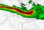
so I've developed a method for tornado intensity and some of the returns I got accounting for linear potential, low level stability were
I'm find it likely that the southern portion near the Dakotas border will go linear. As a result, i found 85-100 mph using the method.
Up north, a ceiling exists for 100-130 mph. This is a highly conditional strong tornado day given the TD spreads bur the opportunity is there. This is a experimental method. This is Saturday, i mistook that you said Saturday but for Sunday, I'll do the returns now.
Yeah, 100-130 mph too. This is for Dakotas and Manitoba.
AS for Tuesday, the results already are quite robust but I'll wait until we get closer
Last edited:
Kds86z
Member
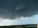
Confirmed tog wisconsin.
CheeselandSkies
Member
Two tornado warnings now. We weren't even in the 2% on the SPC outlook issued an hour ago. Legit couplet on the mini-supercell near Markesan.
WaryWarren
Member
Not Mauston! My favorite Kwik Trip truck stop is there.
WeathermanLeprechaun
Member
Method detected <90 mph tor potential with Wisconsin today. Wish I could've mentioned it earlier but this type of setup is always 50/50, sometimes they don't spin and sometimes they do like today. Those miniature low level curves always get the job doneTwo tornado warnings now. We weren't even in the 2% on the SPC outlook issued an hour ago. Legit couplet on the mini-supercell near Markesan.
Kds86z
Member
jiharris0220
Member
90 over 80, might as well put me in a boiler.

Kds86z
Member
Kds86z
Member
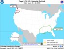
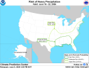
Severe WX Thread 'Severe Weather Threat June 6-14'
We are entering an active period, particularly in the northern plains. An enhanced risk has been issued for tomorrow and a higher end event is possible June 10 as an elongated and potent upper trough will progress across the region with days in between for potential severe wx.
- Kds86z
- Replies: 884
- Forum: General Weather Discussion

Couple timelapses I got of the storms in Des Moines Friday night

Kds86z
Member
Holy signal, Batman! Looks like a very big day is likely on the 18th.


Last edited:
WeathermanLeprechaun
Member
Just so you know, this isn't a one off run. Ensemble guidance is suggesting already that Wednesday is a big day of interest. We will see. To see ASTORP already outline a D6 in JUNE of all months leads to some concern. Plenty of questions but next week will be one to watch...