Kds86z
Member
Very sorry to hear thatDepending on my health, I may try to chase this one. The thought of all that driving with three herniated cervical discs is a little bit daunting though.
Looks like a dangerous setup if it does verify.
Follow along with the video below to see how to install our site as a web app on your home screen.
Note: This feature may not be available in some browsers.
Very sorry to hear thatDepending on my health, I may try to chase this one. The thought of all that driving with three herniated cervical discs is a little bit daunting though.
Looks like a dangerous setup if it does verify.
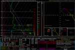
Well this is a straight up unbelievable snapshot from the Euro. Zero chance it verifies, but sure is crazy to imagine.
View attachment 50872
A decent little dryline has definitely come up in the last GFS run or two for the 4th. Are you targeting the Illinois/Missouri area?GFS for the same time period has a similar 500mb pattern, although of course the details vary. Right now it generally shows moisture as being a bit of a question mark, although upper 50s/low 60s are plenty to do the job this time of year.
Right now my interest is more on Wednesday the 4th when the last three GFS runs have had a compact shortwave and surface low moving through the Midwest with some moisture getting pulled up into the triple point. For a good chase opportunity I'd almost want it to slow down a bit from current depictions, right now it has the surface winds veering toward evening. Each successive run since 06Z 2/28 has been a subtle step in that direction, with the instability creeping upward a tad, as well...
A decent little dryline has definitely come up in the last GFS run or two for the 4th. Are you targeting the Illinois/Missouri area?
Agree. Way too overused and no context either to the post on what it means. Awful lot of them do this, just say "oh my" and then it makes people think "uh oh that means bad tornadoes or stuff!!"Of course anything "accumulated" is going to show higher numbers. I am so tired of seeing this map come across my timeline.
Sorry lolAgree. Way too overused and no context either to the post on what it means. Awful lot of them do this, just say "oh my" and then it makes people think "uh oh that means bad tornadoes or stuff!!"
Ugh.
Go chase bruhBring in those warm temperatures! I'll take them, I'm off March 16-20 from work so maybe we will get some severe weather mischief in Alabama that I can follow.
It's not your fault but spreading on those posts does more harm than you would think. They are purposefully trying to lure you into that type of bait. That map has been shared like crazy many times every time one of those large signals show up. A active pattern will accumulate such a signal but it doesn't mean a major day is in the cards. I'm just tired of the community on there always having to overdo stuff. Main reason why I only check informative accountsSorry lol
It's not your fault but spreading on those posts does more harm than you would think. They are purposefully trying to lure you into that type of bait. That map has been shared like crazy many times every time one of those large signals show up. A active pattern will accumulate such a signal but it doesn't mean a major day is in the cards. I'm just tired of the community on there always having to overdo stuff. Main reason why I only check informative accounts
The problem is they give no context to it. It's intended for chasers but for regulars who come across that post with that type of wording, it's gonna come off bad. WXTwitter is a cesspool honestlyI don't think the original post was "sensationalization" so to say. It was clearly intended to hype up chasers in their clique that can also parse the map. The main issue is that it doesn't make sense on here, as a lot of people that visit are more casual and less knowledgable. A lot of twitter posts don't need to be on this forum...
Taken from Southern Michigan on Mar 10. Wildest signal I've seen from the GFS this whole time on this period. There will be major changes but I mean that's a fantasy run to save