tennessee storm chaser
Member
- Messages
- 1,876
- Reaction score
- 4,283
- Location
- jackson tennessee
- Special Affiliations
- SKYWARN® Volunteer
Kind on the sidelines watching this one , extremely Buisy at work. But is it not time start a thread…?
Follow along with the video below to see how to install our site as a web app on your home screen.
Note: This feature may not be available in some browsers.
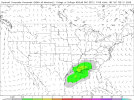
The NAM is in range for Thursday, and i wouldn't exactly say it's a great environment for CI. But thermodynamics are at least there plus the shear. Some sort of severe threat albeit conditional does exist. Strong low level shear plus discrete shear vectors
Well, that's actually fair. D4 15%. I guess I'll go and start it.Kind on the sidelines watching this one , extremely Buisy at work. But is it not time start a thread…?


There won't be much of note on the 20th so i think it's fair this gets a seperate thread. But I do agree, some sort of signal for something (potentially sig?) is there.The signal for the February 21-22 period is pretty darn strong at this point. Do we plan to put this possible event in the same thread as the 2/19 one? If not, it will likely need its own thread, if trends continue.
View attachment 50638View attachment 50639View attachment 50640View attachment 50641View attachment 50642View attachment 50643
This time of year, systems consistently depicted with instability are very much worth keeping a close eye on.Saturday continues to show signals for severe weather on the GFS. The day has remained thermodynamically decent and the kinematics are there too. I would expect uptrends if this event holds but overall, this weekend could get interesting.
Your choice! spc hasn't outlined it yet but there is a ensemble signal and they have noted they could potentially outline it in later updates. So i think we're close to the beginning of discussion with this eventShould I go ahead and pull the trigger on a thread for the 21st-22nd timeframe?
I wouldn’t yetShould I go ahead and pull the trigger on a thread for the 21st-22nd timeframe?
ZCZC SPCSWOD48 ALL
ACUS48 KWNS 170950
SPC AC 170950
Day 4-8 Convective Outlook
NWS Storm Prediction Center Norman OK
0350 AM CST Tue Feb 17 2026
Valid 201200Z - 251200Z
...DISCUSSION...
In general, the latest medium-range guidance indicates that an
initially notable surface cyclone over the upper Great Lakes region
at the outset of the period will undergo substantive weakening, as a
supporting short wave impulse becomes sheared and weakens to the
south of a blocking mid-level ridge centered over southern Hudson
Bay. It appears that secondary cyclogenesis across and offshore of
the Mid Atlantic coast Friday through Friday night will be subdued,
with a trailing cold front stalling across the southern Atlantic
through Gulf coast vicinity into Saturday, near the southern
periphery of the seasonably strong westerlies.
Forcing for ascent associated with trailing short wave
perturbations, emerging from larger-scale mid-level troughing
progressing out of the West, may remain largely to the cool side of
the surface frontal zone. However, further moistening along it
could support sufficient destabilization for vigorous, perhaps
upscale growing and training, thunderstorm development, which could
pose at least some risk for producing severe hail and wind. While
severe thunderstorm probabilities are being maintained at less than
15 percent in this outlook, it is still possible that this could
change in later outlook updates for the Friday/Saturday time period.
Thereafter, amplifying mid/upper flow across the eastern
mid-latitude Pacific into North America through early next week
appears likely to include building large-scale ridging inland of the
Pacific coast through the Mississippi Valley. Beneath the confluent
regime in the wake of digging downstream troughing, cold surface
ridging is forecast to build southward to the lee of the Rockies,
through much of the Gulf Basin. Associated low-level drying and
stabilization probably will tend to limit convective potential
through the remainder of the period.
..Kerr.. 02/17/2026