
Navigation
Install the app
How to install the app on iOS
Follow along with the video below to see how to install our site as a web app on your home screen.
Note: This feature may not be available in some browsers.
More options
-
Welcome to TalkWeather! We see you lurking around TalkWeather! Take the extra step and join us today to view attachments, see less ads and maybe even join the discussion. CLICK TO JOIN TALKWEATHER
You are using an out of date browser. It may not display this or other websites correctly.
You should upgrade or use an alternative browser.
You should upgrade or use an alternative browser.
Severe Weather 2025
- Thread starter KevinH
- Start date
akt1985
Member
Isn’t there a game Saturday night in Baton Rouge? Anyhow, I would be shocked if there are a lot of people Saturday at the Auburn at Arkansas game in Fayetteville. Early kickoff between two bad teams, rainy and raw for October.
AJS
Member

Right in the middle of that 5% risk.
The coastal area near Houston looks pretty volatile with parameters, would say a 10% tornado risk is not out of the equation, but will see. Damaging wind looks like the biggest threat.
imo I think a thread could be warranted for today and tommorow
imo I think a thread could be warranted for today and tommorow
Last edited:
Kds86z
Member
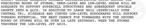
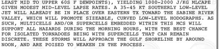
EFFECTIVE DEEP-LAYER SHEAR OF 40-50 KT AS WELL AS MODEST LOW-LEVEL
VEERING WITH HEIGHT WILL FAVOR SUPERCELLS FOR A FEW HOURS, WITH
LOCALLY SIGNIFICANT HAIL POSSIBLE. A TORNADO OR TWO IS POSSIBLE WITH
THE STRONGER SUPERCELLS THAT MAY DEVELOP, WITH SUFFICIENT EFFECTIVE
SRH INCREASING TOWARD 200 M2/S2 BY 00Z
Kds86z
Member
Kds86z
Member
Kds86z
Member
AJS
Member
That’s a pretty nasty sounding. Right near my neck of the woods.
Ozonelayer
Member
We think a 10% hatched could be put out?
WeathermanLeprechaun
Member
I don't see a tornado threat with today, but tomorrow morning, I could definitely see a few embedded tornadoes if a surface inversion can be broke in SE TX. Chances are certainly there but low chance.
Regarding tomorrow in the SE TX vicinity, hope @AJS has safety precautions in place in case a tornadic storm comes by. Personally, the 12z HRRR for SE TX would be trouble but the 18z just rendered in and is a significant flip flop off the last 48 hr run. Here is your deal. If supercells remain surface based tmrw, a couple tornadoes and possibly even a strong one is in the cards but my basis for that is instability. If supercells just are completely elevated, damaging wind and large hail would be the better scenario. Certainly can be a interesting day tmrw and I don't think we may be seeing the full picture just yet.
Regarding tomorrow in the SE TX vicinity, hope @AJS has safety precautions in place in case a tornadic storm comes by. Personally, the 12z HRRR for SE TX would be trouble but the 18z just rendered in and is a significant flip flop off the last 48 hr run. Here is your deal. If supercells remain surface based tmrw, a couple tornadoes and possibly even a strong one is in the cards but my basis for that is instability. If supercells just are completely elevated, damaging wind and large hail would be the better scenario. Certainly can be a interesting day tmrw and I don't think we may be seeing the full picture just yet.
Attachments
AJS
Member
I’ve definitely got a plan in store. I don’t really know how it’s gonna play out, but regardless i’m not taking any chances tomorrow in case one comes by. I’m actually quite nervous because if those storms can fully tap into the environment, a strong tornado is definitely possible.I don't see a tornado threat with today, but tomorrow morning, I could definitely see a few embedded tornadoes if a surface inversion can be broke in SE TX. Chances are certainly there but low chance.
Regarding tomorrow in the SE TX vicinity, hope @AJS has safety precautions in place in case a tornadic storm comes by. Personally, the 12z HRRR for SE TX would be trouble but the 18z just rendered in and is a significant flip flop off the last 48 hr run. Here is your deal. If supercells remain surface based tmrw, a couple tornadoes and possibly even a strong one is in the cards but my basis for that is instability. If supercells just are completely elevated, damaging wind and large hail would be the better scenario. Certainly can be an interesting day tmrw and I don't think we may be seeing the full picture just yet.
AJS
Member
@WeathermanLeprechaun would say the main tornado threat for the Houston metro is more afternoon/evening or more of a morning early afternoon threat?
Kds86z
Member
WeathermanLeprechaun
Member
Can go either way honestly and i think both threats are generally in the same ballpark of intensity. I would just watch out but both sides of the cake are conditional. Regardless, keep your eye out!@WeathermanLeprechaun would say the main tornado threat for the Houston metro is more afternoon/evening or more of a morning early afternoon threat?
Kds86z
Member
Wouldn’t sleep on today either…
WeathermanLeprechaun
Member
Tonight and into early morning in TX should be our tornado threat. Hopefully, prefrontals don't develop but chances are low anyways.Wouldn’t sleep on today either…
akt1985
Member
What is the Sunday threat looking like for the Mississippi/Alabama coasts? Right now the SPC has a marginal threat out for those areas.