TornadoFan
Member

Follow along with the video below to see how to install our site as a web app on your home screen.
Note: This feature may not be available in some browsers.
what is it specifically are you looking for on weather wiseI don’t see that option anywhere with WeatherWise. Do you know any other free sites for this kind of stuff?
Wind velocities right now currentlywhat is it specifically are you looking for on weather wise
831Tornado Warning number #2 in Nebraska at the same time as the current confirmed tornado
View attachment 45254
gotta hit the target icon on the right in the middle of the composite and play pause buttonWind velocities right now currently
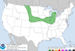
Four (maybe more to come) tornadoes in a 4% chance area!I don’t get it @Atlantic
No longer… now 5%That has to be the largest pure 2% tornado risk I've ever seen. Montana to Colorado to Michigan, wow.
Again? That’s roughly the same area we saw that one tornado last night.Nebraska gonna do Nebraska things?
Several tornadoesAgain? That’s roughly the same area we saw that one tornado last night.
")