
Navigation
Install the app
How to install the app on iOS
Follow along with the video below to see how to install our site as a web app on your home screen.
Note: This feature may not be available in some browsers.
More options
-
Welcome to TalkWeather! We see you lurking around TalkWeather! Take the extra step and join us today to view attachments, see less ads and maybe even join the discussion. CLICK TO JOIN TALKWEATHER
You are using an out of date browser. It may not display this or other websites correctly.
You should upgrade or use an alternative browser.
You should upgrade or use an alternative browser.
Severe Weather 2025
- Thread starter KevinH
- Start date
TornadoFan
Member
Confirmed tornado near Atoka, Oklahoma.
That's one hell of a long line of moisture

CheeselandSkies
Member
Kind of a CYA tornado warning here due to the inexcusable (for being so close to the heart of Tornado Alley) radar hole east of I-35 along the OK/TX line.

Kds86z
Member
Kind of a CYA tornado warning here due to the inexcusable (for being so close to the heart of Tornado Alley) radar hole east of I-35 along the OK/TX line.
View attachment 43629
CYA?
Short for "cover your a**", a.k.a avoiding potential responsibility.CYA?
 Makes sense for a radar hole.
Kds86z
Member
Are there any damage photos from anywhere? Or were all the tornadoes just brief spin ups?
tennessee storm chaser
Member
- Messages
- 1,877
- Reaction score
- 4,283
- Location
- jackson tennessee
- Special Affiliations
- SKYWARN® Volunteer
Could be looking at a fairly significant derecho across the Midsouth Friday. And another one Saturday little further south ….. wind profiles support large swath of damaging winds , SPC mentions upgrade possible
Kds86z
Member
Could be looking at a fairly significant derecho across the Midsouth Friday. And another one Saturday little further south ….. wind profiles support large swath of damaging winds , SPC mentions upgrade possible
Mid south ain’t done :/
Attachments
Central Ohio Wx
Member
Quite off-topic, but there’s a relatively significant severe weather setup taking shape today over Germany and part of west Europe with strong tornadoes possible! I’m not sure if this is the place to put it, but I can’t find a “Europe weather” thread. There’s a level 3, 15% risk (extremely severe), although I’m not exactly sure which risk level that delineates to in the US.
AJS
Member
That’s a large slight risk.Mid south ain’t done :/
Kds86z
Member
Central Ohio Wx
Member

From ESTOFEX:
"
The level 2 was expanded that far S to account for numerous longer tracked supercells in up to 1500 J/kg MUCAPE with 20 m/s DLS. WAA driven (and modified by the local orography) curved hodographs support the mentioned risk with large to very large hail, severe gusts, heavy rain and an isolated tornado. The level 2 was expanded into SE Switzerland as environment becomes steadily supportive for training multicells and supercells, which move into the orography. 6h rainfall amounts in excess of 200 l/qm on a regional scale are possible during the evening into the overnight hours.
Parts of NE Switzerland were added to the level 3. Initiating cells move through a very favorable CAPE shear space for long-lived supercells, which will be accompanied by large hail, severe to damaging gusts and heavy rain. A favorable low-tropospheric stratification with intense SR inflow supports strong/long-lived mesocyclones with a risk of a strong tornado event. We added the level 3, where we expect mature supercells to exit into Germany. We explicitly want to point out that the strong tornado risk extends into the level 2 area over W/N Switzerland.
"
Ozonelayer
Member
So probably the equivalent to a tor-driven MDT risk?View attachment 43631
From ESTOFEX:
"
The level 2 was expanded that far S to account for numerous longer tracked supercells in up to 1500 J/kg MUCAPE with 20 m/s DLS. WAA driven (and modified by the local orography) curved hodographs support the mentioned risk with large to very large hail, severe gusts, heavy rain and an isolated tornado. The level 2 was expanded into SE Switzerland as environment becomes steadily supportive for training multicells and supercells, which move into the orography. 6h rainfall amounts in excess of 200 l/qm on a regional scale are possible during the evening into the overnight hours.
Parts of NE Switzerland were added to the level 3. Initiating cells move through a very favorable CAPE shear space for long-lived supercells, which will be accompanied by large hail, severe to damaging gusts and heavy rain. A favorable low-tropospheric stratification with intense SR inflow supports strong/long-lived mesocyclones with a risk of a strong tornado event. We added the level 3, where we expect mature supercells to exit into Germany. We explicitly want to point out that the strong tornado risk extends into the level 2 area over W/N Switzerland.
"
Central Ohio Wx
Member
I've heard different risks flying around, but I've mainly seen TOR-driven high-end ENH to MDT.So probably the equivalent to a tor-driven MDT risk?
Kds86z
Member
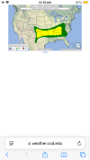
Two days of severe in store for the Mid-South, Southeast and Gulf Coast. SPC mentions possible upgrade to ENH for D3.


Day 3 Convective Outlook
NWS Storm Prediction Center Norman OK
0230 AM CDT Wed Jun 04 2025
Valid 061200Z - 071200Z
...THERE IS A SLIGHT RISK OF SEVERE THUNDERSTORMS FROM THE SOUTHERN
HIGH PLAINS TO THE TN/LOWER OH VALLEYS...
...SUMMARY...
Scattered severe thunderstorms are expected from the southern High
Plains to the Tennessee and Lower Ohio Valleys on Friday into Friday
night.
...Southern High Plains to the TN/Lower OH Valleys...
Enhanced zonal mid-level flow within the southern stream will
overlap a richly moist and unstable air mass across the southern
Great Plains to the TN Valley on Friday. An MCS is expected to be
initially ongoing in the OK vicinity at 12Z Friday. Guidance
generally suggests that the remnant MCV will track east-northeast
across the Mid-South and OH Valley through the period. This should
enhance 700-mb winds and support scattered damaging wind swaths
downstream through at least Friday evening. Have broadened the 15
percent severe area eastward through much of KY south to northern
AL/GA, with still much uncertainty on how far south/east remnant MCS
outflow(s) will reach.
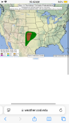
Farther west across the southern High Plains to OK vicinity, the
overall setup from the convective-parameterized guidance appears
conditionally more favorable relative to D2. A broader plume of
large buoyancy is progged across OK/TX by Friday afternoon. In
addition, a northern-stream shortwave impulse is progged to dig into
the central Great Plains by Friday evening/night. This would further
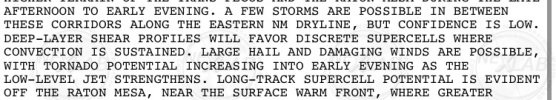
enhance the belt of mid/upper-level westerlies to its south. A
similar evolution of supercells developing off the Raton Mesa
vicinity and growing upscale into a nocturnal MCS seems plausible.
The primary limiting factor to a categorical upgrade is with the
potential impact of the late D2/early D3 MCS on instability and
southern extent of convective outflows, which parameterized guidance
are notoriously underdone with. In addition, there is potential for
that MCS to be more intense/widespread than currently forecast. For
now, have opted to maintain a level 2-SLGT, with potential for
upgrades in later outlooks as limiting impacts of the early-period
MCS are likely better resolved.
..Grams.. 06/04/2025
Day 4-8 Convective Outlook
NWS Storm Prediction Center Norman OK
0351 AM CDT Wed Jun 04 2025
Valid 071200Z - 121200Z
...DISCUSSION...
Another active day characterized by an ongoing MCS and remnant
downstream MCVs is anticipated on D4/Saturday, with a broad belt of
mainly damaging wind potential evident. Seasonably strong mid-level
westerlies are expected to remain coincident with rich low-level
moisture. Ample buoyancy should diurnally develop south of
pre-existing outflows. This multi-day pattern finally breaks down
into D5/Sunday with amplification of a large-scale trough from the
southern Prairie Provinces into the Upper Midwest. Mesoscale-focused
severe potential may linger into at least D5/Sunday over the
southern High Plains to the TX/OK Red River Valley and from the
central Gulf to south Atlantic Coasts.
Otherwise, low-probability severe potential could begin in a portion
of the northern Great Plains on D4/Saturday, in association with the
amplifying trough. This should subsequently shift eastward and
likely broaden across the Great Lakes into the Northeast through
early next week. Overall instability appears modest until a
potential increase later when stronger flow fields overlap richer
low-level moisture. Daily severe probabilities appear to be sub-15
percent at this range, with a relative maximum in the
D6-7/Monday-Tuesday timeframe over the Northeast. Current timing of
this trough exiting New England by around D8/Wednesday suggests a
relative minimum across the CONUS then.
..Grams.. 06/04/2025
Guys it happened! Look at this sounding I just pulled for next Monday! The analog is Palm Sunday. That's a BINGO! We've now seen all the most famous outbreaks on analogs this year. What do I win?

Last edited: