
Alright now… it’s the second time I’ve seen this so far this year. They did it the first time with the thunderstorm contour chances.Ok SPC, there’s no need to be so roundabout with this.
View attachment 43601
Navigation
Install the app
How to install the app on iOS
Follow along with the video below to see how to install our site as a web app on your home screen.
Note: This feature may not be available in some browsers.
More options
-
Welcome to TalkWeather! We see you lurking around TalkWeather! Take the extra step and join us today to view attachments, see less ads and maybe even join the discussion. CLICK TO JOIN TALKWEATHER
You are using an out of date browser. It may not display this or other websites correctly.
You should upgrade or use an alternative browser.
You should upgrade or use an alternative browser.
Severe Weather 2025
- Thread starter KevinH
- Start date
Kds86z
Member
Kds86z
Member
Kds86z
Member
Kds86z
Member
Kds86z
Member
Still tornado warned fyi. Longest lasting tornado warning of day! lol
Kds86z
Member
First tornado of June..
Kds86z
Member
Kds86z
Member
- Moderator
- #4,610
You… do realize that posts don't have to be five quadrillion words to be “quality”, right? Also, it really doesn’t take that long to read through five pages.
You do realize he's not wrong. This thread is for severe weather. We have a thread for weather banter. And members shouldn't have to read through five pages of fluff to find weather information. Some of us are busy.
Central Ohio Wx
Member
Sure, but my other comment after that was about it being said in an overtly-hostile way that really made this forum seem unwelcoming. Is making new members feel unwelcome also not wrong? Hopefully not. Regardless, let’s drop it, this was yesterday and as you say, this thread is for severe weather.You do realize he's not wrong. This thread is for severe weather. We have a thread for weather banter. And members shouldn't have to read through five pages of fluff to find weather information. Some of us are busy.
Last edited:
SPC has delineated D4 and D5 severe weather probability areas for parts of the Southern US. They also mention that another contour will likely be needed for the present D6 period over the Deep South. Organized, consecutive development of MCS complexes are expected.


ZCZC SPCSWOD48 ALL
ACUS48 KWNS 030918
SPC AC 030918
Day 4-8 Convective Outlook CORR 1
NWS Storm Prediction Center Norman OK
0418 AM CDT Tue Jun 03 2025
Valid 061200Z - 111200Z
CORRECTED FOR MISSING LABEL ON DAY 6
...DISCUSSION...
An active severe-weather pattern for repeated MCS development is
anticipated through this weekend, with more nebulous potential early
next week.
Medium-range guidance has converged to above-average consistency
with the large-scale pattern through this weekend. Enhanced zonal
mid-level flow within the southern stream should overlie a
seasonably rich and unstable air mass across the southern Great
Plains to the Deep South. Initial signal for south-central High
Plains nocturnal MCS development spreading east-southeast onto the
lower plains is evident late D3 and this will probably repeat on
D4/Friday night and perhaps on D5/Saturday night. This should
subside as a northern-stream upper trough amplifies into the
north-central states.
Remnant MCVs should focus downstream diurnal thunderstorm
development each afternoon through at least D6/Sunday. Given the
buoyancy/shear parameter space, sufficient confidence exists for
highlighting a scattered severe-storm threat on D4-5. Damaging winds
appear to be the dominant hazard in this pattern. An additional area
on D6 is plausible in later outlooks somewhere in the Deep South and
Gulf Coast States. For D7-8, severe potential is nebulous, but may
be tied to the evolution of the north-central states trough.
..Grams.. 06/03/2025
From the Weather Banter thread on April 23:Alright now… it’s the second time I’ve seen this so far this year. They did it the first time with the thunderstorm contour chances.

Kds86z
Member
Kds86z
Member
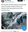
From Reed
SEVERE WEATHER THREAT TODAY ILLINOIS TO TEXAS
We believe there are two areas with relatively higher #tornado potential - (1) central/southern Oklahoma maybe down near the Red River late afternoon and evening and (2) QLCS tornado printer with the linear mode in northeast Missouri into western Illinois.
We will be back LIVE from the Dominator 3 by this afternoon, targeting southern Oklahoma. Stay tuned to watches and warnings!
Kds86z
Member
Kds86z
Member
Rain, rain, rain
Kds86z
Member
Oh my didn’t see this coming.. first tor watch of June.