- Moderator
- #4,101
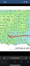
Tornado warning east of Memphis on the TN/MS state line.
Last edited:
Follow along with the video below to see how to install our site as a web app on your home screen.
Note: This feature may not be available in some browsers.
URGENT - IMMEDIATE BROADCAST REQUESTED
Severe Thunderstorm Watch Number 322
NWS Storm Prediction Center Norman OK
205 PM CDT Sun May 25 2025
The NWS Storm Prediction Center has issued a
* Severe Thunderstorm Watch for portions of
Central and Southern Arkansas
Northern and North-Central Mississippi
Southwest Tennessee
* Effective this Sunday afternoon and evening from 205 PM until
900 PM CDT.
* Primary threats include...
Widespread damaging wind gusts to 70 mph likely
Scattered large hail and isolated very large hail events to 2
inches in diameter possible
A tornado or two possible
SUMMARY...Storms are expected to further develop and intensify this
afternoon, including some initial supercells, with lines/clusters of
intensifying storms expected to evolve by late afternoon/early
evening. Damaging winds and isolated large hail are expected to be
the primary hazards.
The severe thunderstorm watch area is approximately along and 85
statute miles north and south of a line from 50 miles west southwest
of Hot Springs AR to 25 miles east southeast of Tupelo MS. For a
complete depiction of the watch see the associated watch outline
update (WOUS64 KWNS WOU2).
PRECAUTIONARY/PREPAREDNESS ACTIONS...
REMEMBER...A Severe Thunderstorm Watch means conditions are
favorable for severe thunderstorms in and close to the watch area.
Persons in these areas should be on the lookout for threatening
weather conditions and listen for later statements and possible
warnings. Severe thunderstorms can and occasionally do produce
tornadoes.
&&
AVIATION...A few severe thunderstorms with hail surface and aloft to
2 inches. Extreme turbulence and surface wind gusts to 60 knots. A
few cumulonimbi with maximum tops to 550. Mean storm motion vector
29030.
...Guyer
The warm mid levels are what caused the meager laspe rates, which prevented the cell from maturing in time (also prevented a wide updraft) before the surface inversion formed.any official sounding from this cell when it was failing?
also would be nice for soundings to show what exact temperature / dew points are on 850 , 700 , 500 mb like how it shows for surface, trying to measure it by hand can result of one of 2 issues
1: off by 1c to 3c
2:you have to slowly restart each calculation because each sounding pages or program has the spot in different spots thus the first way you did it is useless and you have to restart all over again....
yeah uh i was asking if there was a official sounding, to see exactly how it look like in exact numbers , like the skew-t graph?The warm mid levels are what caused the meager laspe rates, which prevented the cell from maturing in time (also prevented a wide updraft) before the surface inversion formed.
The nocturnal surface inversion lifted the LFC above the effective inflow layer and then the dry air from that entrained into the storm, which eroded its cloud base and killed it.
Looks like Reed might have found something

View attachment 43218
Horrible spot if something tries to touch down... (matador)


Thunderstorm watch about to be issued for N. AL, NW GA and southern middle TN until 11 pm.

keep a eye out for east of Lubbock and south of matador in 28 minutes could have a hybrid around there near dickens.
reed timmer is at this cell right now.
The skew Ts shows the surface inversion around the supercell at the time the it was dying.yeah uh i was asking if there was a official sounding, to see exactly how it look like in exact numbers , like the skew-t graph?

Late, I know, but the main threat with hybrids is that they can reach and maintain absolutely terrifying intensities. Three of the tornadoes @joshoctober16 has identified as being hybrids reached E/F5 intensity (Plainfield, Jarrell, Elie), one has been stated as possibly having EF5 winds (Scarif) and two other candidates he didn't mention likely reached EF5 intensity as well (Matador and Greenfield).Isn’t a hybrid tornado just a landspout that transitions into a traditional tornado? What makes those more dangerous?