• Welcome to TalkWeather!
    We see you lurking around TalkWeather! Take the extra step and join us today to view attachments, see less ads and maybe even join the discussion.
    CLICK TO JOIN TALKWEATHER

Severe Weather 2025

Ground breaking research here @Matt and @Fred, you may well have unlocked the "secret sauce" that separates these upper-echelon outbreak patterns. IMO that (apart from the actual process[es] of tornadogenesis itself and if and how they can be predicted) has long been to meteorology what the "cancer moonshot" is to medicine.
 
This is probably going to be difficult to interpret and understand, but I'm going to post what I have been working on with Fred for the last 20 years and in particular after 2011. I began issuing skillful internal forecasts in 2021 using the MJO, but the code had not yet been cracked on large-scale outbreaks for the Deep South. Ironically, this all became much clearer in the last few months leading up to the current March 14-16 expected outbreak. It's truly freaky to see this playing out.

The current MJO (Madden-Julian Oscillation) evolution matches that of April 3, 1974, February 5, 2008 (Super Tuesday), and April 27, 2011. What is not included in this presentation is the Trans-Nino Index, which has an extremely positive value right now that is correlated to seasons with major tornado outbreaks. Not all La Ninas are created equal. Some don't have a positive TNI value, but the 2025 La Nina is special.

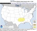
With all of this information in hand, I took the risk of sending this outlook from February 26 to our staff on March 2, highlighting the window of March 14-20 as the most likely time frame for a large-scale tornado outbreak. Additionally, we'll be watching for the next MJO wave in about 40 days. :oops:
This is amazing work that you and @Fred Gossage have done @Matt Grantham. It does seem 4/27 and 4/3/74 took it to another level vs a really high end event like Super Tuesday. I would think some of that is due to April being more favorable for both instability and moisture.

As bad as today’s outbreak was with this background state, if that MJO wave cycles back in mid-late April like you all think it might, with much richer moisture available in the gulf, is it possible we could see one or even two higher end events next month?
i’m going to have to reject the request for another mjo wave in about 40 days.

no thank you.
 
Long-range, isn’t there another system moving through the southern Plains and South next weekend? If there is, will that system bring severe weather? I’m going to Florida next Saturday and don’t want to deal with severe weather. Fortunately, it looks like the chances of severe weather with the mid-week system this coming week is low.
 
I can't seem to access the NOAA TNI page; just gets me the error page. Is there another way to access it? Just asking
It's a simple level math calculation you can work out to always get the TNI value for any daily, monthly, weekly, or archived past ENSO SST anomaly readings you come across. It is simply the SSTA of ENSO Region 1+2 minus ENSO Region 4. (ENSO 1+2) - (ENSO 4). When ENSO Region 4 (the west) is less warm than ENSO Region 1+2 (the east, up against the South American coast), even if it's above average but less above average than ENSO 1+2, the TNI is positive. This happens most often either entering an El Nino or exiting a La Nina. When the eastern ENSO area is less warm than the western ENSO area, the TNI is negative. This is most common when an east-based La Nina is starting to form.

Today's daily CDAS SSTA data shows ENSO 1+2 is at +1.097C, and ENSO 4 is at -0.673. That gives a daily TNI, based on the CDAS data, of +TNI. That is high-end positive. At one point within the past 7-10 days, it peaked at over +2.5, and it was the highest daily value I'd ever seen in real-time since the research paper linking it to tornado outbreaks came out after the 2011 super outbreak. The TNI has come down a little since then, despite still being high-end positive and excruciatingly favorable for big league trouble because of the global propagation of the MJO. You'll see it waffle as those things happen and as the low-level trade winds respond to the MJO forcing on a daily and weekly basis. However, as the MJO continues to propagate, the ENSO 1+2 cooling and ENSO 4 warming have both halted and begun reversing, halting and likely soon reversing that little bit of a drop that's happened to the TNI (which, despite that drop, is still into the high-end positive range).

Matt G and I both feel like, instead of the configuration driving the pattern, it is a dummy light for the pattern and a positive value configuration is put into place by things like the MJO and other factors that drive the large scale weather patterns across the globe. It's all directly linked, but the TNI is likely the equivalent of using a TVS icon or the Baron shear markers and SCITs to identify a tornado signature on radar instead of spotting the couplet in the raw velocity data itself.
 
Seems like we might get isolated severe storm risk at the very least on Wednesday across parts of the Mid-South, but I don't see anything that stands out long term. Of course, I haven't had time to look at forecast models either much recently.
 
Definitely not something you see often. Wondering if they’re seeing potential for another big outbreak.
That did cross my mind. I honestly haven't had time to look at model data.
 
I can start the thread for 3.24 if it's okay with mods.
 
Um.. this is NOT on my BINGO card!! This has got to stop!! I’m supposed to be taking my sis for her Chrons infusion in Atlanta.on day 8…. about an hour away.. do not want to be gone from home and caught out in the middle of something like this past weekend.. somebody enlighten me as to what could transpire.. day 7 circles don’t pop very often.. which is very concerning to me.
 
When it comes to starting a thread for severe weather. Just because there’s a day 6/7 doesn’t necessarily mean it will bring a crazy amount of severe storms. I’d wait until we look more into the kinematics before starting a thread. Sometimes people start one the day on the d1 day so. Let’s see how this goes day by day. But if there is any significant kinematics then we’ll pull a thread together. Just be a tad more patient :).
 
Back
Top