• Welcome to TalkWeather!
    We see you lurking around TalkWeather! Take the extra step and join us today to view attachments, see less ads and maybe even join the discussion.
    CLICK TO JOIN TALKWEATHER

Severe Weather 2025

What does it mean when a storm is considered a "loaded gun"? Is it referring to a strong cap and/or lots of dry air aloft?
 
View attachment 36753
Tornado driven 10% hatched Enhanced Risk. Contemplating canceling my appointment I had scheduled for today to go out chasing in Illinois.
View attachment 36754


Discussion: "A rapidly changing environment is forecast across Illinois today. Extensive cloudcover is expected across the state for much of the day as low-level moisture streams north within a narrow corridor ahead of the cold front. However, by mid to late afternoon, some
clearing is expected which may allow for some brief heating and destabilization across central Illinois. In fact, the HRRR shows what appears to be a dryline by mid afternoon. Mid-level temperatures will be very cold (-22C at 500mb and -4C at 700mb) which will allow for rapid destabilization with only slight heating.
Once destabilization begins ahead of the cold front/dry line, expect thunderstorm development. The wind profile across central and northern Illinois will support supercells, but the intensity of these supercells will be modulated by the instability. 250-500 J/kg MLCAPE will likely be sufficient for supercells capable of all
severe weather hazards. However, if greater destabilization occurs, such as shown by the 00Z HRRR/ 03Z RAP, an even more volatile environment would be present. 56-57F dewpoints would support 1000+ J/kg MLCAPE which is very significant in the low-topped environment
with an EL below 30kft. HRRR/RAP soundings show STP values around 2-3 with very favorable low-level hodograph shapes. Therefore, in the higher instability scenario, multiple tornadic supercells would be possible with the potential for strong (EF2+) tornadoes. While uncertainties remain regarding dewpoints and the amount of clearing/heating along/ahead of the front, an enhanced risk upgrade seems prudent given the expectation for several supercells capable
of all hazards and the conditional potential for a more volatile environment."
Waking up to this was definitely not on my bingo card.
 
A little surprising they pulled the trigger on that at 06z, but cold core setups are very, very notorious for overperforming here in central Illinois. December 1, 2018 (29 tornadoes in IL including an EF3 on a slight risk day) and January 3, 2023 (9 tornadoes within ~50 miles of each other in a marginal risk) both come to mind. Short turnaround from last Friday for sure, but nature stops for no one.

Guess I'm chasing today.
Good luck on you’re chase man!
 
What does it mean when a storm is considered a "loaded gun"? Is it referring to a strong cap and/or lots of dry air aloft?
A very strong cap with extreme instability, where if the cap weakens, storms can explode and become severe within minutes. If you want a good example of this, look up the radar imagery from El Reno 2013, or better yet, look at Pecos Hank's video from him chasing the El Reno tornado that day:

 
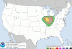
Nothing changed in the latest SPC outlook (at least in the 10% hatched).
1000000669.gif

The SPC seems to be aware of the freat uncertainty, but have this 10% hatched labeled as conditional "worst case scenario"

"...SUMMARY...
Scattered severe thunderstorms are possible this afternoon/evening
from central/northern Illinois to western Indiana. A few tornadoes,
large hail, and damaging wind gusts will be possible.

...IL/IN this afternoon into early tonight...
A deep (989 mb) cyclone near the northeast KS/northwest MO border
will move northeastward to northern IL by this evening and Lower MI
overnight, in conjunction with a deep midlevel trough and 100+ kt
midlevel jet streak. Elevated convection is ongoing this morning in
a zone of focused ascent with warm advection/frontogenesis across
IA, where isolated large hail may occur with MUCAPE around 500 J/kg
and steep midlevel lapse rates/cool midlevel temperatures. The warm
sector of the cyclone is characterized by a narrow/modest corridor
of returning moisture (low-mid 50s boundary-layer dewpoints) that
will overspread MO/IL through the afternoon. Surface heating in
cloud breaks, continued moisture advection and relatively cool
midlevel temperatures will all contribute to warm sector
destabilization (MLCAPE 500-750 J/kg) through the afternoon across
IL.

Surface-based thunderstorm development will become probable by
early-mid afternoon in a broken band along and just ahead of a
remnant dryline moving from MO into IL, and storms will subsequently
move eastward/northeastward into IN by early tonight before
weakening gradually. The deeper buoyancy profiles will be on the
cyclonic side of the midlevel jet, where 500 mb temperatures will be
< -20 C. Forecast wind profiles suggest supercell potential with
long hodographs (effective bulk shear vectors >50 kt), and
sufficient low-level hodograph curvature/shear for tornado
potential. The primary uncertainty centers of the degree of
low-level moistening/destabilization, and the current forecast
represents a conditional/reasonable worst case scenario. Otherwise,
occasional large hail (1-1.5 inches in diameter) will be possible in
IL this afternoon/evening, and the threat for damaging gusts (60-70
mph) and a couple of tornadoes will persist into IN through early
tonight."
 
Yeah, naturally now that they bit on it the HRRR has dramatically backed off its ominous runs from just a few hours ago. Seems the dewpoints will verify on the lower end after all. Still might be a photogenic mini-supercell or two.
Since I'm going out chasing today in the 10%, it 110% won't verify now. Sorry to anyone else who's joining me out there.
 
Sunday's threat has me interested as that could be more MCS potential than anything else. Still a lot to be ironed out and questions to be answered.
 
Looks like we have good bit of reasons to watch the March 30th-April 1st time frame.
Yeah end of month into first week of April does appear to be next period to watch.
 
Back
Top