• Welcome to TalkWeather!
    We see you lurking around TalkWeather! Take the extra step and join us today to view attachments, see less ads and maybe even join the discussion.
    CLICK TO JOIN TALKWEATHER

Severe Weather 2025

So anyone want to explain why this lone storm moving thru Oxford, MS doesn't have a Tornado Warning or Tornado Possible Tag on the SVRC? Clearly, the storm has broad rotation
 

Attachments

  • Oxford MS Storm April 27th 25.png
    Oxford MS Storm April 27th 25.png
    2.5 MB · Views: 0
So anyone want to explain why this lone storm moving thru Oxford, MS doesn't have a Tornado Warning or Tornado Possible Tag on the SVRC? Clearly, the storm has broad rotation
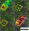
I'd have to assume they are anticipating that meso won't make it to the ground, given a lack of low-level kinematics. Definitely producing some nasty hail, though, and if there's any rule to follow religiously, it's never trust gas after BBQ and never trust a pulse storm in Mississippi.
 
After this trough blows through, the upcoming pattern is incredibly strange and I really can't make heads or tails of it. Globals are consistent in showing another big trough digging in towards the west, but they seem to slow it down before it can fully eject at peak strength over the Plains, then have it slowly meander to the east looking much more anemic. The GFS is being extremely goofy and has been fully on-board with a trough retrograding back to the west from over the Atlantic in the past few runs starting around the ~212 hour mark, which the Euro completely disagrees with.

I will say, the trough that's being modeled that moves in after this one looks like quite the chonker, but pretty much all the globals seem to slow it down substantially before it really has a chance to do much, at least from my perspective. I'd love to hear thoughts from a MET here, the pattern is weird and I can't make sense of it, but this upcoming trough looks like trouble if it can eject fully.
 
Back
Top