Sawmaster
Member
Not liking the look in upstate SC. We've still got leaning trees from Helene all over the upstate area and they'll be coming down with the next good storm. Can we please wait till spring for this?
Follow along with the video below to see how to install our site as a web app on your home screen.
Note: This feature may not be available in some browsers.
I hate it for the Carolinas especially getting into the colder months. I hope y'all can avoid a big ice storm or any significant weather event for a while.Not liking the look in upstate SC. We've still got leaning trees from Helene all over the upstate area and they'll be coming down with the next good storm. Can we please wait till spring for this?


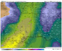
Day 2 Convective Outlook
NWS Storm Prediction Center Norman OK
1129 AM CST Sun Dec 08 2024
Valid 091200Z - 101200Z
...NO SEVERE THUNDERSTORM AREAS FORECAST...
...SUMMARY...
Thunderstorms are possible from the Lower Mississippi Valley into
much of the Southeast States on Monday. The probability for severe
thunderstorms appears low.
...Synopsis...
A mid/upper-level trough covering much of the CONUS is forecast to
amplify further on Monday, as multiple shortwaves move through the
large-scale trough. One shortwave trough is forecast to move quickly
from the OH/TN Valley region toward the Mid Atlantic during the day,
as a trailing low-amplitude shortwave trough moves from Texas into
the Southeast. Farther north and west, a strong shortwave trough
will move across the Great Lakes region, while another shortwave
will dig southeastward from the Great Basin into the
Southwest/southern Rockies. At the surface, a weak cyclone is
forecast to move eastward from north TX toward the ArkLaMiss region,
as a trailing cold front approaches the TX Gulf Coast vicinity.
...Lower MS Valley/Southeast/Mid-South...
Seasonably rich low-level moisture (with 60s F dewpoints) will
continue to gradually spread northward across parts of the Southeast
on Monday, in advance of the approaching cold front and weak surface
low. Some weak convection will likely be ongoing Monday morning near
the central Gulf Coast vicinity within a zone of low-level
warm/moist advection. This convection may persist through the day,
though some weakening and veering of low-level flow is expected as
the lead midlevel shortwave trough moves quickly away from the
region toward the Mid Atlantic. Late in the period, as midlevel
height falls associated with the amplifying large-scale trough
overspread the region, convection may redevelop near the Gulf Coast
vicinity, and also farther north toward the Mid-South.
Deep-layer flow/shear will be conditionally favorable for organized
convection through the forecast period, but weak low/midlevel lapse
rates are expected to limit instability with both early-day
convection and also with any development later Monday night. The
weak instability is expected to limit the organized-severe threat,
but a strong storm or two cannot be ruled out, and probabilities may
need to be considered if trends support stronger
heating/destabilization than currently forecast.
..Dean.. 12/08/2024
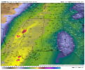
Day 3 Convective Outlook
NWS Storm Prediction Center Norman OK
0226 AM CST Sun Dec 08 2024
Valid 101200Z - 111200Z
...THERE IS A MARGINAL RISK OF SEVERE THUNDERSTORMS ACROSS PORTIONS
OF SOUTHERN AL...SOUTHWEST GA...AND THE ADJACENT FL PANHANDLE...
...SUMMARY...
Isolated severe thunderstorms are possible across portions of
southern Alabama, southwest Georgia, and the adjacent Florida
Panhandle on Tuesday.
...Synopsis and Discussion...
Deep upper troughing is forecast to cover much of the CONUS early
Tuesday, anchored by a shortwave trough moving into the southern
High Plains. This shortwave is expected to continue eastward across
the southern Plains and Lower MS Valley, ending the period over the
TN Valley. Progression of this shortwave will foster a more neutral
tilt to the parent upper troughing while also significantly
strengthening the mid-level flow through its eastern periphery.
Consequently, a belt of 100-120 kt 500 mb flow will likely extend
from AL into the central Appalachians early Wednesday morning.
At the surface, a low associated with a leading shortwave trough is
expected to progress from the ArkLaMiss northeastward through the TN
Valley. As it does, an attendant cold front will push across the
Southeast. By early Wednesday, this front will likely extend from a
low over eastern PA southwestward through the eastern FL Panhandle.
A moderately moist warm sector will precede this front,
characterized by mid 60s dewpoints throughout much of the region.
Even with this low-level moisture in place, overall buoyancy will be
mitigated by poor lapse rates and relatively warm profiles.
While buoyancy will be minimal (i.e. less than 750 J/kg),
surface-based storms appear probable along and just ahead of the
front during the afternoon across portions of southern AL, southwest
GA, and the adjacent FL Panhandle. The strengthening low to
mid-level flow will result in long hodographs indicative of an
environment that supports organized storm structures. A gradually
narrowing warm sector will likely limit the eastern extent of the
severe threat.
..Mosier.. 12/08/2024


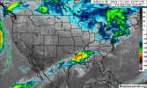
Tornado Warning
National Weather Service Birmingham AL
930 AM CST Tue Dec 10 2024
The National Weather Service in Birmingham has issued a
* Tornado Warning for... Northern Hale County in west central Alabama...
* Until 1030 AM CST.
* At 930 AM CST, a severe thunderstorm capable of producing a tornado was located over Wedgeworth, or 8 miles east of Eutaw, moving northeast at 30 mph.
HAZARD...Tornado.
SOURCE...Radar indicated rotation.
IMPACT...Flying debris will be dangerous to those caught without shelter. Mobile homes will be damaged or destroyed. Damage to roofs, windows, and vehicles will occur. Tree damage is likely.
* Locations impacted include... Wedgeworth, Evansville, Harper Hill, Wateroak, Phipps, and Havana.
PRECAUTIONARY/PREPAREDNESS ACTIONS...
TAKE COVER NOW! Move to a basement or an interior room on the lowest floor of a sturdy building. Avoid windows. If you are outdoors, in a mobile home, or in a vehicle, move to the closest substantial shelter and protect yourself from flying debris.
&&
TIME...MOT...LOC 1530Z 244DEG 28KT 3282 8775
TORNADO...RADAR INDICATED
MAX HAIL SIZE...<.75 IN
$$
56


THAT PART!Another example of why you don't dismiss or write off a severe threat just because of a "Marginal" environment.