- Thread starter
- #2,981
KevinH
Member
I guess that’s one thing we will have to wait and see, but it is THAT time though…Wow, will there be any substantial instability though?
Also, we all know Dixie doesn’t follow “the rules” either sooooooo lol
Follow along with the video below to see how to install our site as a web app on your home screen.
Note: This feature may not be available in some browsers.
I guess that’s one thing we will have to wait and see, but it is THAT time though…Wow, will there be any substantial instability though?
Right…Two things to keep in mind is that global models have a hard time picking up on instability in the long range and you don't need more than 1000 CAPE to lead to a substantial severe weather threat across the Gulf States during the Fall/Winter months. Plus don't get hug up on the tilt of the trough either. Both positive and negative tilted troughs can produce violent outbreaks as the great @Fred Gossage has pointed out multiple times.


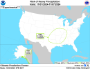
Risk area for OK… in November? I don’t remember that happening before? HmmmWednesday:
View attachment 31193
October…Risk area for OK… in November? I don’t remember that happening before? Hmmm


..THERE IS AN ENHANCED RISK OF SEVERE THUNDERSTORMS FOR PORTIONS OF
EASTERN KANSAS INTO FAR NORTHEASTERN OKLAHOMA AND NORTHWESTERN
MISSOURI...
...SUMMARY...
Strong/severe thunderstorms, capable of producing large hail,
damaging wind gusts, and a few tornadoes, are expected today into
early tonight, particularly from the middle Missouri Valley area
into the southern Plains.
...Synopsis...
A pronounced mid-level trough will traverse the Plains and become
negatively tilted as it impinges on the Upper MS Valley today.
Surface lee-troughing will remain in place across the Plains,
resulting in the northward transport of an appreciably moist
low-level airmass. A surface low will develop along the KS/OK border
this afternoon and track toward the MS Valley this evening. A cold
front will be draped across the MS Valley into KS while a dryline,
extending from the low, is poised to sweep eastward across OK and
northern TX through the day. Deep-layer ascent along and ahead of
the cold front and dryline will support at least scattered
thunderstorm initiation by late afternoon across the Plains. These
storms will progress eastward amid a buoyant and highly sheared
airmass. Severe storms are likely ahead of the cold front and
dryline, with all hazards possible.
...Upper MS Valley into the southern Plains...
Thunderstorms are expected to first initiate along the cold front
over northern KS into western IA by mid to late afternoon as
stronger upper-level support from the impinging mid-level trough
overspreads the terminus of a 50+ kt southerly low-level jet. 7+
C/km mid-level lapse rates, overspreading rich low-level moisture
(including mid-60s F surface dewpoints), should yield at least 1500
J/kg SBCAPE. Strong southwesterly 500 mb flow overspreading the
low-level jet will contribute to 50+ kts of effective bulk shear,
but with vectors aligned roughly parallel with the front. Initial
semi-discrete storm modes, capable of mainly severe wind/hail, will
quickly merge to form a QLCS with embedded bowing segments and
perhaps a few mesovortices. This initial band of storms should
approach the MS Valley region by sunset, accompanied by mainly
damaging gusts and perhaps an isolated tornado threat.
Farther south into central KS/northern OK, more discrete
thunderstorm development is expected by early evening. Surface
temperatures in the upper 70s F, combined with mid to perhaps upper
60s F dewpoints, will contribute to 1500-2000 J/kg MLCAPE just
before sunset. Storms that can mature in this environment may
benefit from over 50 kts of effective bulk shear, as well as an
increase in low-level shear upon approaching the western periphery
of the low-level jet. Forecast soundings depict overall curved
low-level hodographs with mid-level elongation and 250-350 m2/s2
effective SRH. As such, supercells should be the initial storm mode
before storm mergers result in squall line development. While many
forecast soundings depict a weakness in the 800-600 mb layer, the
overall strength of the low-level shear suggests at least a few
tornadoes are possible, and a strong tornado or two may occur,
mainly after dark. The severe threat may transition to more of a
damaging gust threat after the squall line forms, though
line-embedded QLCS tornadoes remain possible.


SUMMARY...
Thunderstorms, associated with isolated severe wind gusts, will be
possible Thursday afternoon along a narrow corridor from the Sabine
River Valley north-northeastward into far southern Lower Michigan.
...Sabine River Valley/Lower to Mid Mississippi Valley/Lower Ohio
Valley/Southern Great Lakes...
A negatively-tilted upper-level trough, and an associated 70 to 80
knot mid-level speed max, will move northeastward into the Great
Lakes on Thursday. At the surface, a cold front will advance
eastward into the Ark-La-Tex and mid Mississippi Valley. Ahead of
the front, surface dewpoints in the 60s F will contribute to weak
destabilization in most areas by midday. Convection is expected to
initiate along and ahead the front during the late morning as
surface temperatures warm. Thunderstorms should gradually increase
in coverage in the afternoon, moving eastward across the lower to
mid Mississippi Valley, and lower Ohio Valley.
Model solutions appear to present two scenarios. The first solution,
which is depicted by the NAM, initiates convection near the front
around midday from east-central Texas north-northeastward into the
mid Mississippi Valley, with a second north-to-south band of storms
developing much further east in the lower Mississippi Valley. The
second solution, which is depicted by the ECMWF, focuses most of the
convection further east near the center of the low-level moisture
corridor in the lower to mid Mississippi Valley. Strong outflow from
the previous night's convection is forecast to surge southeastward
across much of central and east Texas Thursday morning, which could
favor the second scenario, with an effective frontal boundary much
further east.
The severe threat should be concentrated along and near the axis of
the strongest low-level flow, which is forecast to be in the lower
to mid Mississippi Valley, and lower Ohio Valley. Forecast soundings
near the moist axis in the afternoon have MLCAPE peaking from around
500 J/kg in the lower Ohio Valley to 1500 J/kg in the lower
Mississippi Valley. Moderate deep-layer shear is forecast along much
of the moist axis, where low-level lapse rates could peak near 7
C/km in areas that heat up the most. This environment will likely
support an isolated wind-damage threat during the afternoon, with
the stronger and more organized multicells. A marginal tornado
threat may also develop, mainly from western Tennessee
south-southwestward into northern Louisiana, where the combination
of instability and shear is forecast to be maximized, in conjunction
with steep low-level lapse rates.
Looks like a good chance of severe storms in the same areas along with parts of the south, next week also.
The alleys are starting to wake up. Let’s hope they don’t throw a toddler sized tantrum.Yep...
...Tuesday/Day 7 and Wednesday/Day 8...
The upper-level trough is forecast to move quickly northeastward
into the Great Lakes region on Tuesday, as mid-level flow remains
southwesterly across the lower to mid Mississippi Valley. Isolated
to scattered thunderstorms are expected to form Tuesday afternoon
ahead of a cold front from the lower to mid Mississippi Valley
north-northeastward into the lower Ohio Valley. On Wednesday, the
front is forecast to move southeastward into the Ohio and Tennessee
Valleys, suggesting the potential for isolated severe thunderstorms
would be greatest from Kentucky southwestward into western Tennessee
and northern Mississippi. However, spatial and magnitude uncertainty
are substantial at this range.