...DISCUSSION...
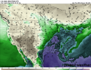
A shortwave trough is forecast to move across the southern Plains
and into the Lower MS Valley on D4/Friday. Strong mid-level flow
will precede this shortwave, spreading eastward from the Lower MS
Valley across the Southeast. Airmass across the Lower MS Valley will
likely be characterized by dewpoints in the low/mid 70s, with strong
instability developing ahead of the approaching shortwave. Severe
thunderstorm development is anticipated as the shortwave and
associated surface low interact with this unstable and strongly
sheared airmass. The timing of thunderstorm development and favored
convective mode remains uncertain, but the overall environment and
potential severe merits introducing a small 15% area from central LA
into central/southern MS.
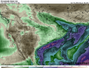
The severe potential may extend into D5/Saturday across AL, GA, and
FL Panhandle/northern FL as the shortwave trough continues eastward.
However, uncertainty regarding convective evolution from D4/Friday
as well as a less favorable severe environment precludes introduce
any outlook areas.


")