
Yeah. I figure we'll get another heavy rain/severe threat before we head into another cold snap going into MarchThe models are showing most activity between Feb 22 - Feb 29. It would be right on schedule with what we typically see in February. Usually 2 or 3 severe days spaced out every 10-14 days.
Navigation
Install the app
How to install the app on iOS
Follow along with the video below to see how to install our site as a web app on your home screen.
Note: This feature may not be available in some browsers.
More options
-
Welcome to TalkWeather! We see you lurking around TalkWeather! Take the extra step and join us today to view attachments, see less ads and maybe even join the discussion. CLICK TO JOIN TALKWEATHER
You are using an out of date browser. It may not display this or other websites correctly.
You should upgrade or use an alternative browser.
You should upgrade or use an alternative browser.
Severe Weather 2024
- Thread starter KevinH
- Start date
I'm enjoying this warmth today. Can't wait for spring, warm weather and thunderstorms!
Good cheat sheet for all the goobers like me lol.

 cameronjnixon.wordpress.com
Parameters
This is a comprehensive “cheat sheet” of severe convective weather parameters. Definitions of parameters can be found here. Composite parameters and simple “rule-of-thumb” i…
cameronjnixon.wordpress.com
- Moderator
- #584
The models are showing most activity between Feb 22 - Feb 29. It would be right on schedule with what we typically see in February. Usually 2 or 3 severe days spaced out every 10-14 days.
Yep, that’s the period to watch.
CheeselandSkies
Member
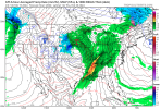
GFS has been pretty consistent with fast 500mb flow over most of the CONUS with lots of pieces of energy flying around throughout the latter part of the month. However, that's about the only thing it's been consistent with. Timing, amplitude and orientation of any coherent trough ejection, and thus timing, location and ceiling of any potential severe threat, all very much up in the air at this range.
Timhsv
Member
Yes, still long range....BUT..this is outbreak criteria at the moment with these type of CAPE and EHI values.If the trough at 500mb and wind fields comes into a productive pattern setup


CheeselandSkies
Member
Yes, still long range....BUT..this is outbreak criteria at the moment with these type of CAPE and EHI values.If the trough at 500mb and wind fields comes into a productive pattern setup
View attachment 23898
View attachment 23897
The breadth and quality of that warm sector would be almost unheard of for the time of year. I say almost because 2/28/2017 happened. That might be the most impressive run yet, although obviously way the heck far out and unlikely to verify verbatim. But every time I think the atmosphere can't possibly pull something off (this time, a tornado in Wisconsin in early February with dewpoints in the 40s), it surprises me.
It would make sense for a severe weather threat late month since we should go back into a winter cold type pattern in March
tennessee storm chaser
Member
- Messages
- 1,877
- Reaction score
- 4,288
- Location
- jackson tennessee
- Special Affiliations
- SKYWARN® Volunteer
That cold spell March starting not look as promising … verifies at all won’t last …. Look for a active spring severe season as we head towards a La Niña ensoIt would make sense for a severe weather threat late month since we should go back into a winter cold type pattern in March
To me, March might be similar to that of 2011. Few outbreaks here and there, but not as active as the last few Marches. April though is gonna be a different story.
That's mad chonkers. Let's lock that in lolYes, still long range....BUT..this is outbreak criteria at the moment with these type of CAPE and EHI values.If the trough at 500mb and wind fields comes into a productive pattern setup
View attachment 23898
View attachment 23897
ashtonlemleywx
Member
February always reminds me of the 1971 Mississippi Delta Outbreak. The anniversary is on Feb 21. Produced a long track F4 and F5 (Before enhanced fujita).
Death toll was high and it leveled numerous towns in the Delta that still haven't recovered to this day.
As long as I've been a chaser, this outbreak has facinated me more than anything else.
If you go Google this outbreak you'll find a pdf that NOAA produced in its aftermath.

Death toll was high and it leveled numerous towns in the Delta that still haven't recovered to this day.
As long as I've been a chaser, this outbreak has facinated me more than anything else.
If you go Google this outbreak you'll find a pdf that NOAA produced in its aftermath.
- Moderator
- #594
Yes, still long range....BUT..this is outbreak criteria at the moment with these type of CAPE and EHI values.If the trough at 500mb and wind fields comes into a productive pattern setup
This is a weather weenie run of the ages.
ashtonlemleywx
Member
06z GFS still has decent trough on Feb 27th. GFS has consistently simulated one in the Feb 26 - Feb 28 timeframe.
Euro will be in range for this tmrw but it's showing hint of a trough forming on the last frame of the 00z run.
Going with my gut to say something will most likely happen in that timeframe, especially since it would be right on schedule with our typical February pattern.
Euro will be in range for this tmrw but it's showing hint of a trough forming on the last frame of the 00z run.
Going with my gut to say something will most likely happen in that timeframe, especially since it would be right on schedule with our typical February pattern.
ashtonlemleywx
Member

CSimonds
Member
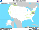
Looks like Mississippi again this year
March 2011 was relatively inactive tornado wise across MS. Only 3 tornadoes in NWS Jackson CWA and none across North MS.
CheeselandSkies
Member
Yup, as I said yesterday, definite signal for something in that timeframe but way too far out to even attempt to pin down specifics at this point.