
Navigation
Install the app
How to install the app on iOS
Follow along with the video below to see how to install our site as a web app on your home screen.
Note: This feature may not be available in some browsers.
More options
-
Welcome to TalkWeather! We see you lurking around TalkWeather! Take the extra step and join us today to view attachments, see less ads and maybe even join the discussion. CLICK TO JOIN TALKWEATHER
You are using an out of date browser. It may not display this or other websites correctly.
You should upgrade or use an alternative browser.
You should upgrade or use an alternative browser.
Severe Weather 2024
- Thread starter KevinH
- Start date
I had just read this article over on the AlabamaWX blog regarding the forecast:
Could be 500 Year Flood for Los Angeles | Alabama Weather Network
 www.alabamawx.com
The message in that article stood out in particular (emphasis added by the article):
Area Hydrological Discussion #027 – EXPERIMENTAL
NWS National Water Center – Tuscaloosa, AL
1231 PM CST Sun Feb 04 2024
WHAT: Considerable flash, urban, and small stream flooding
WHERE: Southern California
WHEN: Through this evening
FORECAST RAINFALL AND ANTECEDENT CONDITIONS:
QPF: 2 – 4″, locally higher (HRRR)
QPE: up to 2″ (MRMS past 12 hours)
Rates: up to 1.5/hr (HRRR)
Soils: 60 – 80% (0 – 10 cm RSM, NASA SPoRT)
Streamflows: Much above normal (USGS)
DISCUSSION…
Moderate to heavy rainfall will continue to shift southward,
increasing the chances of flooding impacts across the area of
concern. Light to moderate rainfall through this morning has slowly
increased soil moisture and infiltration capacity will continue to
decrease farther south as the moisture continues to move southward
through the early afternoon, priming the area for increasing flood
threat later today and through tonight. Locally heavy rainfall will
easily convert to overland flow over the region resulting in isolated
considerable flash and urban flooding impacts.
The HRRR-Forced NWM SRF continues to indicate the potential of
Rapid-Onset Flooding (ROF) with scattered probabilities between 50 –
75% and locally higher probabilities. Additionally, MHFM continues to
indicate widespread AEPs around 20%, with an increasing number of
streams falling below 20% suggesting isolated significant higher
streamflows. This increases confidence in the potential for
significant river rises, especially since the SRF does not cover the
entire event yet. Towards the end of this AHD and potentially
overnight, considerable flooding concerns will increase as the HRRR
continues to indicate the potential for 6 hr accumulations up to 6
near Los Angeles, which would be equivalent to a 500 yr + rainfall
event or 0.2% AEP (ATLAS 14). This trend will continue to be watched,
and a subsequent AHD will most likely be needed.
GRAPHICAL REPRESENTATION weather.gov/owp/operations-ahd
Some of the video out there is ridiculous. Flooding can be very scary especially at nightI had just read this article over on the AlabamaWX blog regarding the forecast:
Could be 500 Year Flood for Los Angeles | Alabama Weather Network
The message in that article stood out in particular (emphasis added by the article):
CheeselandSkies
Member
Nick Stewart is from Iowa; what the heck is he doing chasing a marginal risk in Florida in early February? Must be desperate, lol.
Just getting caught up on this thread; had other things going on yesterday because suffice it to say an outbreak of multiple highly visible, photogenic supercells/tornadoes was not on my weather bingo card.
CheeselandSkies
Member
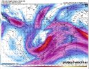
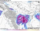
12z Euro for Monday. @UncleJuJu98
That run would be significant trouble next Sunday-Monday; but the 0Z run that came in overnight has a much smaller warm sector with the surface low/warm front hugging close to the coast.
Sunday
.png")

pritchlaw
Member
Big time lull in the action in Central/North Alabama.
Here you go guys! @TH2002 you were right about ef2 lol
Jackson not really sold on the weekend threat
Meh. They'll come around to the idea. Mid-60s to low 70s in February always leads to trouble.Jackson not really sold on the weekend threat
- Moderator
- #454
With how we've seen the trough and surface low trend with time, I wouldn't right this off yet. The idea of a more favorable setup for severe is not totally lost in different operational model runs and ensemble guidance.
Agreed!With how we've seen the trough and surface low trend with time, I wouldn't right this off yet. The idea of a more favorable setup for severe is not totally lost in different operational model runs and ensemble guidance.
- Moderator
- #456
Agreed!
The trough presence while it is out west has already improved.

CheeselandSkies
Member
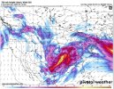
Yup, right on cue the next 12Z run is game on, depicting significant cyclogenesis with a broad warm sector pushing deep inland. Now to see if the 0Z run holds that or again flips back to a less potent look.
Last edited:
That's a really good warm sector for mid February on the globals. Sheesh.From the 12z Euro