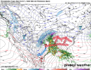
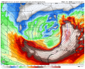
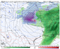
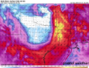
January Deep South/Southeast Severe Weather Events: (1990s to current)
January 23rd-24th, 1997 (Level 4-Moderate Risk) (January ENSO Status: Neutral)
January 17th-18th, 1999 (1) (Unknown Risk level) (January ENSO Status: 3 year La Nina)
January 21st-23rd, 1999 (2) (Level 5-High Risk) (January ENSO Status: 3 year La Nina)
January 7th-11th, 2008 (Level 4-Moderate Risk) (January ENSO Status: La Nina)
January 22nd-23rd, 2012 (Level 4-Moderate Risk) (January ENSO Status: Weakening La Nina transitioning to Neutral)
January 29th-30th, 2013 (Level 4-Moderate Risk) (January ENSO Status: Neutral)
January 21st-23rd, 2017 (Level 5-High Risk) (January ENSO Status: Neutral)
January 10th-11th, 2020 (Level 4-Moderate Risk) (January ENSO Status: Neutral)
January 12th, 2023 (Level 3-Enhanced Risk) (January ENSO Status: Weak La Nina transitioning to Neutral)


.png")

.png")

.png")