- Moderator
- #321
Can someone make a new thread please so today doesn't get lost in this general severe thread? I would, but nah.
Follow along with the video below to see how to install our site as a web app on your home screen.
Note: This feature may not be available in some browsers.
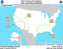
Bingo! Weesa gonna flood again. Goodbye drought! LOL!A lot of rain (left), and maybe some severe (right) later this week according to CIPS.
View attachment 23679View attachment 23680
yep another big rain event for the south, i am not seeing much on the severe weather side to get hyped up about for awhileBingo! Weesa gonna flood again. Goodbye drought! LOL!
If this pattern keeps up, its just a matter of timeyep another big rain event for the south, i am not seeing much on the severe weather side to get hyped up about for awhile
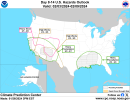
Well someone should inform MEG of this because they're not seeing it. LOL!CIPS-ER showing a strong signal for persistent heavy rain heading towards this weekend, and again at the end of the period. Could definitely be a substantial flood threat for parts of the South, especially near the Gulf Coast.
View attachment 23685View attachment 23686View attachment 23687View attachment 23688
yep another big rain event for the south, i am not seeing much on the severe weather side to get hyped up about for awhile
I'm sure this was mentioned in another thread, and not sure when they will put this into effect, but this was discussed again at the AMS meetings this week: