• Welcome to TalkWeather!
    We see you lurking around TalkWeather! Take the extra step and join us today to view attachments, see less ads and maybe even join the discussion.
    CLICK TO JOIN TALKWEATHER

Severe Weather 2023

Source: https://www.cpc.ncep.noaa.gov/products/precip/CWlink/MJO/mjoupdate.pdf

• While low frequency variability is predominately featured in the global tropics, the
reemergence of a more coherent MJO signal is evident. The uptick of intraseasonal
activity constructively interfered with El Nino and likely triggered an unusually strong
westerly wind burst event over the equatorial Pacific during mid-November.
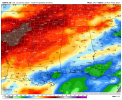
• Dynamical models remain in good agreement depicting continued eastward propagation
of the MJO over the Indian Ocean and into the Maritime Continent during the next
several weeks. Favored increases (decreases) in amplitude in RMM space appear to be
tied to constructive (destructive) interference with the +IOD (El Nino and other modes of
variability) in the forecast period.
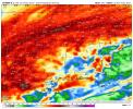
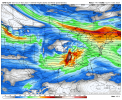
• The large scale environment is expected to remain conducive for tropical cyclogenesis
over the Indian Ocean through the end of November, with more favorable conditions for
development shifting eastward into the Pacific later in the outlook period.
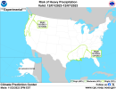
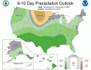
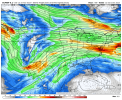
• The extratropical response associated with eastward propagating Indian Ocean MJO
events during late autumn typically leads to the development mid-level ridging and
above-normal temperatures over the central and eastern U.S.
 
Slight Risk of Heavy Precipitation early December
 

Attachments

  • precip_probhazards_d8_14_contours.png
    precip_probhazards_d8_14_contours.png
    334 KB · Views: 0
While I do think we'll have another severe weather threat next month (probably east Texas through Gulf States), the 12z Canadian and Euro today are in agreement in another dose of much needed rainfall thru next 10 days. GFS not so much. Still not enough to break the drought yet, but we'll take what we can.

Need a good 5+ inch from a storm system.
 

Attachments

  • gem-all-alms-total_precip_inch-1691200.png
    gem-all-alms-total_precip_inch-1691200.png
    145.7 KB · Views: 0
  • ecmwf-deterministic-alms-total_precip_inch-1691200.png
    ecmwf-deterministic-alms-total_precip_inch-1691200.png
    171.8 KB · Views: 0
While I do think we'll have another severe weather threat next month (probably east Texas through Gulf States), the 12z Canadian and Euro today are in agreement in another dose of much needed rainfall thru next 10 days. GFS not so much. Still not enough to break the drought yet, but we'll take what we can.

Need a good 5+ inch from a storm system.
CPC agrees:
 

Attachments

  • 610prcp.new (1).gif
    610prcp.new (1).gif
    956.6 KB · Views: 0
All 12z model runs have a system around the above timeframe that Reed has indicated. However, the Euro is a little slower than the GFS/Canadian.
 

Attachments

  • ecmwf-deterministic-conus-z500_speed-1518400.png
    ecmwf-deterministic-conus-z500_speed-1518400.png
    224.6 KB · Views: 0
  • gem-all-conus-z500_speed-1421200.png
    gem-all-conus-z500_speed-1421200.png
    201.9 KB · Views: 0
  • gfs-deterministic-conus-z500_speed-1432000.png
    gfs-deterministic-conus-z500_speed-1432000.png
    207.9 KB · Views: 0
If any of you are interested, my article on the history of North MS tornadoes has been posted online. I do weather articles for my local county newspaper now.
 
If any of you are interested, my article on the history of North MS tornadoes has been posted online. I do weather articles for my local county newspaper now.
Congrats! Will definitely give it a read.
 
Thoughts?


Well all the 12z runs had the system and the 18z GFS did as well. As I previously mentioned, the 12z Euro was slower than the GFS/Canadian. Other than that, I don't have anything else to add except the pattern is gonna get very active going into December especially with the Southern jet kicking up.
 
Well all the 12z runs had the system and the 18z GFS did as well. As I previously mentioned, the 12z Euro was slower than the GFS/Canadian. Other than that, I don't have anything else to add except the pattern is gonna get very active going into December especially with the Southern jet kicking up.
“Very active” :oops:
 
SPC 4-8/day outlook:

General height rises are then forecast over much of the South Friday/D6 through Sunday/D8 as another possible shortwave trough moves across the Rockies. This pattern will favor showers and thunderstorms over much of the Southeast, and the next trough evolution will need to be monitored into next weekend as moisture will be in place along the Gulf Coast.
 
Back
Top