Austin Dawg
Member
I just shared some egg nog with a couple of Texas sized mosquitos.
Follow along with the video below to see how to install our site as a web app on your home screen.
Note: This feature may not be available in some browsers.
I just shared some egg nog with a couple of Texas sized mosquitos.

Where do you get these images from?The 18z GFS CWASP valid the 29th and then the 31st.
Where do you get these images from?
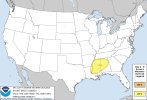
Falling right on everybody's favorite day of the week, too.SPC has a D5 15% out. They say there's a good bit of uncertainty but there's enough confidence to at least put a 15% there for now.
Seeing areas like most ms into Alabama into parts of Tennessee likely Fred if things do line up kind what I’m thinking .It's definitely more of a Saturday/Sunday threat, and not starting Friday (not even late, unless something significantly changes). There are still questions about overall timing and evolution of the wave... the potential for anticyclonic flow aloft out ahead of the front and how much that would impact things since it's subtle and there are other things present to try to make up for it. However, with that broad of a warm sector, deep low-level tropical moisture sitting to our south for days, and the broad-based but intense nature of the wave overall, it has the potential to become another large-scale significant event if everything lines up correctly. One thing is already clear though. Barring any radical changes, this one is aimed farther south than December 10-11 was.
By leaps, bounds, and back handsprings, I think the system next weekend has a much better chance at being something than the Wednesday ordeal does...
...D7-8/Sat-Sun - Portions of the Southeast...
The last several runs of the ECMWF and GFS show advancement of the
western CONUS upper-level trough which moves eastward across the
CONUS as a positively tilted trough. This would be higher amplitude
than any of the shortwave troughs which are forecast to cross the
Plains this week. An amplified mid-level trough interacting with a
broad warm sector with mid to upper 60s dewpoints could lead to a
significant severe-weather episode. There are still considerable
differences in the timing and amplitude of this advancing
upper-level trough, which can be seen comparing not only the
operational long-range model suite, but also the varying solutions
within the GEFS. However, despite these differences, virtually all
the members show the potential for a severe weather event sometime
on Saturday or Sunday. The lack of run-to-run model consistency and
timing differences are too great to include probabilities at this
time. However, if these uncertainties become more clear in the
coming days, probabilities may need to be added.
Have there been some significant tornado outbreaks that coincided with a similarly west-based -NAO and anticyclonic flow aloft over the Southeast?the potential for anticyclonic flow aloft out ahead of the front and how much that would impact things
Not sure . Good question can’t really remember be honest. Perhaps some one else over my head can answer that .Have there been some significant tornado outbreaks that coincided with a similarly west-based -NAO and anticyclonic flow aloft over the Southeast?