• Welcome to TalkWeather!
    We see you lurking around TalkWeather! Take the extra step and join us today to view attachments, see less ads and maybe even join the discussion.
    CLICK TO JOIN TALKWEATHER

Archive Severe Weather 2019

Status
Not open for further replies.

Equus

Member
Messages
3,290
Reaction score
3,368
Location
Jasper, AL
Special Affiliations
  1. SKYWARN® Volunteer
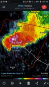
Couple tornadoes and a vigorous little MCV this morning... pretty active start to the day for Texas
 

warneagle

Member
Messages
3,729
Reaction score
3,208
Location
Arlington, VA
Special Affiliations
  1. SKYWARN® Volunteer
Hopefully these guys won’t get any ideas about producing again as they move into the Houston metro.

We’ve got a couple of severe storms firing back near the WV/VA line but they won’t make it to the metro for a few hours, unlike yesterday when we got pounded right at rush hour—and when I forgot to close the windows at my apartment before I left for work :(
 

akt1985

Member
Messages
1,009
Reaction score
509
Location
Madison, Alabama
What are the models showing as far as severe weather and heavy rain for next week? The way I’m understanding this next system, the period will be more annoying for the Tennessee Valley and the Mid-South with the flooding rain and severe weather centered in the same area over the southern Plains into Missouri.
 

Taylor Campbell

Moderator
Moderator
PerryW Project Supporter
Messages
2,102
Reaction score
2,189
Location
Wedowee, AL
Special Affiliations
  1. SKYWARN® Volunteer
Operational runs of many global models, and their ensemble members are indicative of a potentially active week of severe weather May 5th-11th. These threats could extend outside of the Plains.

We are within 7 days, and there has been growing support for this to become a reality. Mid week into next weekend looks active with rather robust severe weather events possible into the Southeast states.
 
Messages
1,031
Reaction score
1,220
Location
jackson tennessee
Special Affiliations
  1. SKYWARN® Volunteer
What are the models showing as far as severe weather and heavy rain for next week? The way I’m understanding this next system, the period will be more annoying for the Tennessee Valley and the Mid-South with the flooding rain and severe weather centered in the same area over the southern Plains into Missouri.
day 6 looking very interesting for mid south... models starting to converge on a pretty significant event possible... little early to go in great detail... I be keeping up with this threat as next week rolls along.
 

akt1985

Member
Messages
1,009
Reaction score
509
Location
Madison, Alabama
day 6 looking very interesting for mid south... models starting to converge on a pretty significant event possible... little early to go in great detail... I be keeping up with this threat as next week rolls along.

I was supposed to drive from Huntsville to Bowling Green/Mammoth Cave in Kentucky on Friday for the weekend. It looks like I may have to cancel that trip or at least postpone it until after Labor Day when hotel prices drop.
 

Lori

Administrator
Staff member
Administrator
Moderator
Messages
1,035
Reaction score
653
Location
Vandiver, AL
Special Affiliations
  1. SKYWARN® Volunteer
My friend took these photos of a shelf cloud at MM180 (on I-65) near Prattville. They received small hail, torrential rains and lightning. It went from a significant advisory to severe.... it’s causing some damage!


7892EC3B-42E2-45C2-BA3E-B119E02634A7.jpeg6667F80C-2445-480D-8A3A-9028A9AA288F.pngC90A1636-2BB3-4049-8E67-EA2F333315C7.png66EFE720-77B5-4DB2-974E-DEA9CA1165A2.png
 
  • Like
Reactions: KoD

warneagle

Member
Messages
3,729
Reaction score
3,208
Location
Arlington, VA
Special Affiliations
  1. SKYWARN® Volunteer
Very strong signature just north of Adrian, TX. Could be a significant tornado on the ground there. Looks like it's going to miss the town thankfully but if it keeps going it's going to cross I-40 at some point.
 

bwalk

Member
Messages
597
Reaction score
291
Location
Prattville, Al
My friend took these photos of a shelf cloud at MM180 (on I-65) near Prattville. They received small hail, torrential rains and lightning. It went from a significant advisory to severe.... it’s causing some damage!


View attachment 1633View attachment 1634View attachment 1635View attachment 1636

I drove through this in Montgomery this afternoon. Had to pull off I85 onto the shoulder due to rain so hard you could not see the vehicles in front of you or beside you. Many other vehicles did the same Very dangerous situation for about 10 minutes.
 
Messages
1,031
Reaction score
1,220
Location
jackson tennessee
Special Affiliations
  1. SKYWARN® Volunteer
Thursday starting to raise eyebrows... midsouth region... shear values on models pushing range 50 60 kts... cape reaching near 2500... lapse rates nearly off chart thus far... spc already mentions super cell storm mode....
 
Messages
1,031
Reaction score
1,220
Location
jackson tennessee
Special Affiliations
  1. SKYWARN® Volunteer
Could this be the May 2003 pattern setting up?
believe it or not... I was actually thinking the same thing... that was also an elnino enso period... I had a ef4 hit my city... may 4th 2003... 12 fatalities... I got some good vid shots of that violent tornado though it took place at night if I can find it...
 

Mike S

Administrator
Staff member
Administrator
Moderator
PerryW Project Supporter
Messages
1,991
Reaction score
1,115
Location
Meridianville, Al
Special Affiliations
  1. SKYWARN® Volunteer
believe it or not... I was actually thinking the same thing... that was also an elnino enso period... I had a ef4 hit my city... may 4th 2003... 12 fatalities... I got some good vid shots of that violent tornado though it took place at night if I can find it...

hit a college there, correct?
 
Messages
1,031
Reaction score
1,220
Location
jackson tennessee
Special Affiliations
  1. SKYWARN® Volunteer
hit a college there, correct?
that tornado that hit the college union university... occurred super Tuesday 2008... ef4 also... the one 2003 did destroy a middle school... thank god it happened at night sunday night... cause my daughter was going at that school during that time... thngs could have been much more worse...
 
Messages
1,031
Reaction score
1,220
Location
jackson tennessee
Special Affiliations
  1. SKYWARN® Volunteer
cant believe the lack of chater on this up comings severe wx threat... todays 12z runs support super cells out ahead boundary... starting southern plains into the Ozarks late wed... and again further east for later thrusday.... look for spc put 30 percent zone mornings udate for southern plains ozrk then things could get further east for Thursday with 30 percent in Tuesdays morning update.... lapse rates r huge so large hail going be factor.
 
Status
Not open for further replies.
Back
Top