AJS
Member
Decent hook forming on that storm. Velocity looks a bit meh, but if any storm right now we’re to drop something, it would be this one.
Follow along with the video below to see how to install our site as a web app on your home screen.
Note: This feature may not be available in some browsers.
The storm to the south near Bement, IL looks a lot more interesting.That storm from Tinley Park to Kankakee IL is showing signs of weakening, at least part of the southern side.
I understand in a way why the SPC wants to expand the watch, but I just don't see the appeal of these storms like they do, including the environment. I just feel like as they get further east, they'll die, but more likely I'll just eat my words. Perhaps I also have just become insanely numb to outflow dominant, non tornadic storms, like the usual here in northern IN.


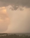
Man, I miss Chicago. Was a beautiful city to visit.Amazing view of the rain column on the north Chicago supercell, taken from my apartment
How about the storm to the south near Bement?Temps/dew po
Storm near Kankakee has a 50,000 foot echo top and is entering a much more favorable environment soon, it also looks like it's trying to break off the main line so we'll see if it gets its act together in the next hour or so.
View attachment 41709View attachment 41710
This entire line is entering into a much more favorable environment, but yet I highly doubt it strengthens back up, which I do not understand why. Bizarre setups like today make me so happy that I'm not a meteorologist.Temps/dew po
Storm near Kankakee has a 50,000 foot echo top and is entering a much more favorable environment soon, it also looks like it's trying to break off the main line so we'll see if it gets its act together in the next hour or so.
View attachment 41709View attachment 41710
How about the storm to the south near Bement?


You’ve got to be kidding me…View attachment 41715
Oh come on.
I think a 15% hatched is definitely on the table for tomorrow. That is a nasty run.View attachment 41715
Oh come on.
Agreed. Semi discrete/discrete cells in a very favorable environment for intense tornadoes is a recipe for disaster. Honestly, a mid-high end 15% hatched is definitely in order is his trend keeps up.I think a 15% hatched is definitely on the table for tomorrow. That is a nasty run.


HRRR needs to relax with southern Illinois and western Kentucky. No matter the solution for Friday those areas are either hit with tornadic supercells or a possible derecho.View attachment 41719
lil close up of 0z hrrr, o u c h not what we wanted to see
That area is Tornado Warned now too. Radar Indicated.What am i looking at here over Lake Michigan? Is that inflow? Pretty huge area of 70+ mph winds in the blue. The dark blue is 80 mph.
View attachment 41718