I'm just gonna take a gamble and say the RAP is being wonky lol. Also has 3km EHI of 10-11 over Mississippi.Can you send a pic?


Follow along with the video below to see how to install our site as a web app on your home screen.
Note: This feature may not be available in some browsers.
I'm just gonna take a gamble and say the RAP is being wonky lol. Also has 3km EHI of 10-11 over Mississippi.Can you send a pic?
Why?Friday looks to be looking more and more dangerous.
Because of the images I posted above. Although, I wanna see if the 00z hrrr jumps on with this idea! Not sure if the RAP has a bias or anything but it looks rather worrisome lolWhy?
Right, but that's exactly my point. Currently the SPC has no way of factoring in highly conditional threats where the outcome is likely to be a high-end event, or nothing.I think they're doing decent because
1. SPC forecasts are more for local meteorologists than regular citizens, and the messaging has been pretty detailed about the current level of uncertainty and potential ceiling. It's up to the local mets to communicate the range of possible outcomes to their regions.
2. Once the SPC is locked into a higher risk forecast, it's impossible to dial it back. It was pretty clear to meteorologists 24 hours before the April 27th event that nothing too serious was going to materialize in a large portion of the hatched area, but they had already communicated the 15-30% hatched risk.
Even finding a way to communicate the floor and ceiling of events would be tough, because sometimes even when conditions end up being perfect, something unforeseen stops it from reaching its true potential. The SPC has an impossible job because any amount of over confidence can erode public confidence when it doesn't pan out. I expect they'll upgrade the risk area even more if things keep trending more confidently in a bad direction. They still have two more updates before things kick off.
Who going to tell them their method is wrong.Right, but that's exactly my point. Currently the SPC has no way of factoring in highly conditional threats where the outcome is likely to be a high-end event, or nothing.
The forecasters have to work within this framework and do the best they can. I'm suggesting the framework is flawed and should be revisited for these types of setups.
Oh yeah duh sorry. I’m out of it and working. I did see the day 3 enhanced earlier and tornadoes mentioned.Why?
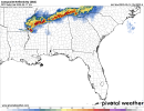
Looked at 21Z RAP and spit out my drink. Likewise, NAM 3km shows a very concerning parameter space out ahead of a nasty MCS making its way southward through TN into AL/GA/MS. Wanna see more consistency on this as the time frame gets a little better in-range on the CAMs, but it certainly gives me cause for concern. The presence of a weakening cap out ahead of the MCS could also allow for storms to retain greater intensity.I'm just gonna take a gamble and say the RAP is being wonky lol. Also has 3km EHI of 10-11 over Mississippi.
View attachment 41495View attachment 41496


Eagerly awaiting 00z HRRR lolLooked at 21Z RAP and spit out my drink. Likewise, NAM 3km shows a very concerning parameter space out ahead of a nasty MCS making its way southward through TN into AL/GA/MS. Wanna see more consistency on this as the time frame gets a little better in-range on the CAMs, but it certainly gives me cause for concern. The presence of a weakening cap out ahead of the MCS could also allow for storms to retain greater intensity.
View attachment 41500View attachment 41501
I think it's safe to assume that this is one of those events where if the SPC could initiate that 5% hatched for tornadoes, they definitely would.Right, but that's exactly my point. Currently the SPC has no way of factoring in highly conditional threats where the outcome is likely to be a high-end event, or nothing.
The forecasters have to work within this framework and do the best they can. I'm suggesting the framework is flawed and should be revisited for these types of setups.
I wonder if they will ever do that.I think it's safe to assume that this is one of those events where if the SPC could initiate that 5% hatched for tornadoes, they definitely would.
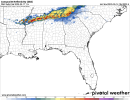
You talking about Friday or tomorrow?00z HRRR gets too warm (my main concern) with inverted-V thermodynamic profiles down south, which leads to an outflowy mess.
Tomorrow. Friday is a tornado outbreak across the Mid South on the 00z HRRR.You talking about Friday or tomorrow?
Does that long track cell that originates in Missouri and into Kentucky still show up on the latest HRRR run? Haven’t had time to check.Tomorrow. Friday is a tornado outbreak across the Mid South on the 00z HRRR.
View attachment 41462
Took this sounding from the north central IN/MI border. NAMNST is only the model that really pays respect to tomorrow's ingredients and has the cap breaking (although that's the usual I feel like from the model). Although I would vew this as the *worst case scenario* (peep the Moore 1999 tornado analog). In all, HRRR/NAM/GFS/RAP kind of just laugh tomorrow off and have the cap remain in place.
I'm going to be honest, I kind of give the IWX area a 20-30% of anything occuring. I'm with the NWS IWX MET's on this event in terms of confidence.

Does that long track cell that originates in Missouri and into Kentucky still show up on the latest HRRR run? Haven’t had time to check.

Sheesh thats a nightmare...View attachment 41509
This is what the HRRR shows.