• Welcome to TalkWeather!
    We see you lurking around TalkWeather! Take the extra step and join us today to view attachments, see less ads and maybe even join the discussion.
    CLICK TO JOIN TALKWEATHER

Severe Threat May 15-16, 2025

So if the Nam overdoes dew points, and the HRRR under-does it, would the middle ground be more supercells than the HRRR shows and more isolated than the NAM shows? Even the HRRR (which barely shows convection) has blips turning into supercells with cloud tops over 50,000 feet within 2 hours.

1747251323760.png

This little guy blows up in less than an hour.

1747251521070.png
 
Here's a sounding I pulled from northern Indiana close to the Michigan border at 01z for the 18z HRRR. This is out ahead of a few cells that popped up too. Notice the 5/3/99 OKC analog that has continued to pop up for a while now:
View attachment 41485

It's interesting how high up and drastic the dry region is here. Is the dryline sharper higher up in the atmosphere? I'm heading out so can't look myself right now.
 
Thought I would offer my two cents into the 18z HRRR run. It's now joined the party, and the enviornment it presents itself in the IWX area has skyrocketed. You have SRH 0-1km in the 350-400+ range with some values peaking above 500 (might be contaminated I don't know). If this cap breaking holds on past the 00z and 06z run, the SPC will 100% move that 10% hatched TOR risk down into IWX. Still not enough to introduce a MOD risk (they shouldn't), because of this still clearly being a conditional type threat on if the cap breaks.
 
I'm a broken record, but once again I'll state that the SPC forecasting methods are inadequate for these types of conditional setups (conditional)
A 10% hatched tornado risk doesn't capture the ceiling of the event at all, nor does it explicitly allow for Forecasted Convective Amplification Deficiency scenarios.
 
1747252422148.png 1747252449390.png

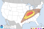
...THERE IS AN ENHANCED RISK OF SEVERE THUNDERSTORMS SOUTHEAST
MISSOURI...SOUTHERN ILLINOIS/INDIANA...SOUTHWEST OHIO...AND PORTIONS
OF WESTERN TO NORTHERN KENTUCKY...

...SUMMARY...
Severe thunderstorms are expected across the Middle Mississippi and
Ohio Valley region Friday afternoon and evening. All-severe hazards
are possible with this activity. More isolated severe thunderstorms
will extend southwestward into northeast Texas, and northeast into
the Mid-Atlantic.

...Mid-South/Ohio Valley vicinity...

An upper trough over the southern High Plains will pivot quickly
east/northeast across the Midwest on Friday. As this occurs, strong
mid/upper southwesterly flow will overspread the region, with a 500
mb jet around 70-90 kt forecast. At the surface, A very moist
airmass will be in place from southern MO into southern IL and
northeast into OH. Increasing southerly low-level flow ahead of a
surface cold front will allow a warm front, roughly along the I-70
corridor at mid-morning, to lift north toward the northern IL/IN/OH
through the afternoon. Cooling aloft will result in steep midlevel
lapse rates atop the mid/upper 60s F dewpoint surface warm sector,
resulting in strong destabilization.

A low-level jet around 45-65 kt is forecast to overspread the region
from peak heating into the evening, coincident with increasing
large-scale ascent. Both the eastward-advancing cold front/dryline
across MO, and the warm front vicinity will be a focus for
convective initiation. One or more bowing clusters is possible, in
addition to more discrete supercells. Given vertically veering
supercells wind profiles, significant severe storms appear possible
-- with a risk for all hazards accompanying this activity, including
very large hail, tornadoes, and intense wind gusts. The southward
extent of highest severe potential is a bit uncertain given
orientation of surface boundaries and potential overnight convection
in the Day 2/Thursday time period impacting parts of the KY
vicinity.

Eventually, a northeast to southwest line of storms will likely
congeal during the late evening/nighttime hours and sag southward
across KY into the TN Valley, with a gradually lessening severe risk
with southward extent during the overnight hours.

...TX into OK/AR...

With southwest extent, severe potential is a bit more
uncertain/conditional. Some minor height rises may occur across TX
and the into AR during the late afternoon/evening. Large-scale
ascent will be weaker and any capping may be more difficult to
overcome. Nevertheless, a very moist and unstable airmass will be in
place amid supercell wind profiles. If storms can develop, very
large hail and strong gusts will be possible.

...Mid-Atlantic Vicinity...

Convection may be ongoing in a warm advection regime Friday morning
as a weak shortwave impulse moves across the region through
afternoon. Moderate mid/upper flow will support effective shear
magnitudes around 25-35 kt, and be sufficient for some organized
convection. Pockets of stronger heating downstream from morning
activity will allow for weak to moderate destabilization. Isolated
strong to severe storms producing hail and gusty winds will be
possible.

..Leitman.. 05/14/2025

Given the current expected timing, I'm not concerned about the tornado threat in my neck of the woods at this stage. That said, I'm gonna need to find a garage for my car Friday night or prepare my bank account for a new windshield.
 
The RRFS did a better job than the HRRR predicting the severe storms on May 2nd across North MS. It has also done better than the HRRR with the recent storm activity as well for North MS.
 
Wording has definitely been shifted towards a more concerned tone from the METs at IWX.

This is from their latest post:

They ended up replying to someone asking about the 10% TOR shifting southward. This was their response:

"Not sure, that call is ultimately up to SPC. Hodographs look favorable for tornadoes though (especially with the low level SRH) and it's definitely possible that a few supercells are long-lived tomorrow night along the warm front."
 
I'm a broken record, but once again I'll state that the SPC forecasting methods are inadequate for these types of conditional setups (conditional)
A 10% hatched tornado risk doesn't capture the ceiling of the event at all, nor does it explicitly allow for Forecasted Convective Amplification Deficiency scenarios.

I think they're doing decent because

1. SPC forecasts are more for local meteorologists than regular citizens, and the messaging has been pretty detailed about the current level of uncertainty and potential ceiling. It's up to the local mets to communicate the range of possible outcomes to their regions.

2. Once the SPC is locked into a higher risk forecast, it's impossible to dial it back. It was pretty clear to meteorologists 24 hours before the April 27th event that nothing too serious was going to materialize in a large portion of the hatched area, but they had already communicated the 15-30% hatched risk.

Even finding a way to communicate the floor and ceiling of events would be tough, because sometimes even when conditions end up being perfect, something unforeseen stops it from reaching its true potential. The SPC has an impossible job because any amount of over confidence can erode public confidence when it doesn't pan out. I expect they'll upgrade the risk area even more if things keep trending more confidently in a bad direction. They still have two more updates before things kick off.
 
Back
Top