Kds86z
Member
in a watch and hearing thunder.
Follow along with the video below to see how to install our site as a web app on your home screen.
Note: This feature may not be available in some browsers.


im seeing people say that friday and possibly tomorrow has tornado(es) written all over it and a possible t word outbreak with supercells unfortunately on wxtwitter with a mcv might possibly be hype you chasing cheeselandskies and grand poo bah


What's more likely? Hybrid tornadoes or regular supercellular tornadoes?Barely a cloud in the sky in Iowa right now, but I did just notice two clouds moving perpendicular to each other, high up in the atmosphere, and they looked like they were separated by only a few hundred feet elevation. First time I can ever recall seeing that. Things are definitely spinny if any supercells decide to pop up.

i saw one time while at night time there were clouds flying on by but not too terribly fast or at least what it looked like of course they are going pretty fast at the level of the atmosphere they were at but the moon was shining brightly and gave illumination to the clouds moving on by at the different levels of the atmosphere at the time but all of it was interesting none the less this was from december last year (2024)Barely a cloud in the sky in Iowa right now, but I did just notice two clouds moving perpendicular to each other, high up in the atmosphere, and they looked like they were separated by only a few hundred feet elevation. First time I can ever recall seeing that. Things are definitely spinny if any supercells decide to pop up.

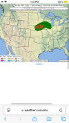
May get some tornadoes during this period after all.View attachment 44988
Bit of a cherrypicked screenshot but this is valid in about 4 hours from now. nasty outsome with some discrete supercells in central-eastern and even western Nebraska. Valid via the latest HRRR run.