
Definitely not something I'm accustomed to seeing in the Deep South in early August, that's for sure.What’s more impressive to me is the lower level wind shear later this evening for august . In this part country for sure
Navigation
Install the app
How to install the app on iOS
Follow along with the video below to see how to install our site as a web app on your home screen.
Note: This feature may not be available in some browsers.
More options
-
Welcome to TalkWeather! We see you lurking around TalkWeather! Take the extra step and join us today to view attachments, see less ads and maybe even join the discussion. CLICK TO JOIN TALKWEATHER
You are using an out of date browser. It may not display this or other websites correctly.
You should upgrade or use an alternative browser.
You should upgrade or use an alternative browser.
Severe WX Severe Threat 8/9-8/10 2023
- Thread starter StormStalker
- Start date
Weatherphreak
Member
That will be something to watch this afternoon for the first complex of storms since the better wind shear won’t be in play till tonight.Does seem that summer CAPE gives a big boost to the STPs, though as we've seen sometimes big CAPE can overcome lesser dynamics.
.png")
Looks like SPC has made room for a Level 4 Moderate Risk upgrade. If so, it would be the 6th Moderate this Summer and the first Moderate in August for the above area since August 1st, 2003.
12Z CAMs guidance is split on the location of the first round of convection, with HRRR (left) keeping it far north AL and TN and NAM 3km (right) and WRF bringing it into Central AL. Will be interesting to see how this evolves. Second round, in the form of an MCS, looks to affect most of us regardless, so everyone needs to be on the lookout for that one, which will happen well after dark.


O..... Wow!Also worth noting - the 12Z HREF guidance pops a 15% tornado contour on the 4-hour probability metric right over the triple-point of MS/AL/TN.
View attachment 21316
warneagle
Member
Little bit of clearing now over SW Missouri and far NW Arkansas behind the MCS. Should get some time to recover at least but the question is just gonna be how big of a window we get from initiation until everything grows upscale. If it can stay discrete for more than a couple hours though that’s gonna be a big problem.
- Thread starter
- Moderator
- #33
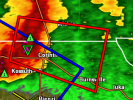
Rotating Wall cloud reported near Corinth, MS. TOR warned.
Severe Thunderstorm Watch issued:

Gusted out but that's a stout mini squall line entering NW AL now.Nasty looking couplet over Corinth.
- Thread starter
- Moderator
- #37
It’ll be here pretty soon. Hope to get a few shots of the shelf cloud.

18Z CAMs guidance is showing some rather favorable parameters across parts of Alabama after this current convection in the northern parts of the state move out ahead of the larger MCS likely arriving later tonight. From the HRRR at 04Z.

- Thread starter
- Moderator
- #40
The lightning is pretty bad but not much wind.