
- Moderator
- #1
Have at it.
Follow along with the video below to see how to install our site as a web app on your home screen.
Note: This feature may not be available in some browsers.


Good. Lord.Just ..wow...00Z THU right over Limestone County. Look at that STP of 10. This is August of coarse, but this is alarming somewhat
View attachment 21297
Good grief!Just ..wow...00Z THU right over Limestone County. Look at that STP of 10. This is August of coarse, but this is alarming somewhat
View attachment 21297

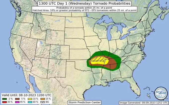
First August 10% SIG hatch on record for that area. First 5% in August for North MS since 2012 (outside of a tropical system), and First 5% in August for North AL on record (outside of a tropical system).10% hatched Tornado area for latest outlook
Wonder if the STP is over doing it due to the high CAPE values we have this time of year? Brad mentioned in one of his streams the EHI seemed a bit over blown and said it was probably due to CAPE.Just ..wow...03Z THU right over Limestone County. Look at that STP of 10. This is August of coarse, but this is alarming somewhat
View attachment 21297
Does seem that summer CAPE gives a big boost to the STPs, though as we've seen sometimes big CAPE can overcome lesser dynamics.Wonder if the STP is over doing it due to the high CAPE values we have this time of year? Brad mentioned in one of his streams the EHI seemed a bit over blown and said it was probably due to CAPE.
What’s more impressive to me is the lower level wind shear later this evening for august . In this part country for sureDoes seem that summer CAPE gives a big boost to the STPs, though as we've seen sometimes big CAPE can overcome lesser dynamics.
