
Navigation
Install the app
How to install the app on iOS
Follow along with the video below to see how to install our site as a web app on your home screen.
Note: This feature may not be available in some browsers.
More options
-
Welcome to TalkWeather! We see you lurking around TalkWeather! Take the extra step and join us today to view attachments, see less ads and maybe even join the discussion. CLICK TO JOIN TALKWEATHER
You are using an out of date browser. It may not display this or other websites correctly.
You should upgrade or use an alternative browser.
You should upgrade or use an alternative browser.
Severe WX Severe Threat 8/7/23
- Thread starter StormStalker
- Start date

CheeselandSkies
Member
Fine time for State College, PA radar to be down with a tornado-warned supercell right next to it. Nearest alternative radar is Pittsburgh and that's hitting the storm at like 14,000'.
Knoxville also.Fine time for State College, PA radar to be down with a tornado-warned supercell right next to it. Nearest alternative radar is Pittsburgh and that's hitting the storm at like 14,000'.
Radar down in the middle of a severe weather event? I am shocked I tell you...Fine time for State College, PA radar to be down with a tornado-warned supercell right next to it. Nearest alternative radar is Pittsburgh and that's hitting the storm at like 14,000'.
CheeselandSkies
Member
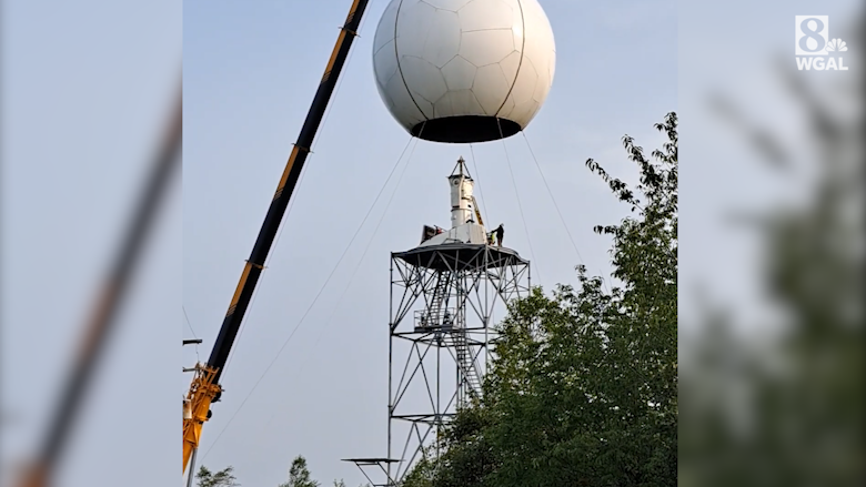
NWS radar in State College under repair
The National Weather Service in State College says their radar will be offline for about two weeks for repairs and upgrades.
 www.wgal.com
The weather service says adjacent radars will be available to fill in the radar data gap while the State College radar is offline.
*CoughBULL****!cough*
TH2002
Member
- Messages
- 4,974
- Reaction score
- 11,116
- Location
- California, United States
- Special Affiliations
- SKYWARN® Volunteer
Thought my mind was playing tricks on me at first, but thanks for confirming. Just freakin' wonderful to know the radar-borne epidemic of Radarus Inoperabilius is showing no signs of slowing...Fine time for State College, PA radar to be down with a tornado-warned supercell right next to it. Nearest alternative radar is Pittsburgh and that's hitting the storm at like 14,000'.

warneagle
Member
All of the federal offices are dismissing at 3 so I’m hitting the bricks before the trains get crowded. I guess everybody up here is getting the experience of a tornado day. They looked at me like I had two heads when I explained that this was a normal thing at home lol
warneagle
Member
Looks like the supercells that are popping in western MD and eastern WV are growing upscale pretty quickly. The intermediate balloon from Roanoke shows plenty of CAPE and impressive LLLRs but the wind profile is pretty unidirectional. The window for discrete convection might be pretty small.
I know the NWS offices up here sent up balloons at 2 but they’re not showing up on the SPC archive yet.
I know the NWS offices up here sent up balloons at 2 but they’re not showing up on the SPC archive yet.
NWS needs to work with private weather companies or something to provide back up radar systems.
I'm sure GWX is about to go down again since a storm just passed by.NWS needs to work with private weather companies or something to provide back up radar systems.
warneagle
Member
I'm running for president on a single-issue campaign in 2028. #MakeRadarGreatAgainNWS needs to work with private weather companies or something to provide back up radar systems.
Probably so.I'm sure GWX is about to go down again since a storm just passed by.
warneagle
Member
The sun has been out here for at least an hour straight which is...concerning even if the dynamics aren't favorable for tornadoes. We also got a lot of rain last night and I don't think it will take a lot of wind to bring down a lot of trees here, especially when we're still repairing infrastructure from the downburst we got last Saturday. I'm not that worried about my neighborhood because all of our utility lines are buried but a lot of the area where they're above ground lost power for hours/days last week.
Chris3024
Member
Some strong winds moving through Cullman right now. Sitting in a parking lot and It’s rocking the car
warneagle
Member
Yeah that tracks with some of the other soundings (like the Roanoke one I mentioned above). The prefrontal cells that popped are really struggling to stay discrete.
- Moderator
- #37
Some strong winds moving through Cullman right now. Sitting in a parking lot and It’s rocking the car
Yeah, it got hairy here for a while. And without power for the second day in a row!
- Moderator
- #38
So, was that it or will there be more later?
Was just looking at the 18z HRRR. It has another complex of storms moving through North MS into Alabama between roughly 8am through 1pm tomorrow. The 18z 3km NAM has a similar idea.So, was that it or will there be more later?
warneagle
Member
Well I take that back, there's a pretty healthy-looking supercell right on the MD/PA line south of Gettysburg. Rotation isn't that tight though.