

Navigation
Install the app
How to install the app on iOS
Follow along with the video below to see how to install our site as a web app on your home screen.
Note: This feature may not be available in some browsers.
More options
-
Welcome to TalkWeather! We see you lurking around TalkWeather! Take the extra step and join us today to view attachments, see less ads and maybe even join the discussion. CLICK TO JOIN TALKWEATHER
You are using an out of date browser. It may not display this or other websites correctly.
You should upgrade or use an alternative browser.
You should upgrade or use an alternative browser.
Severe Threat 8/10-13
- Thread starter Seasons of weather
- Start date

WeathermanLeprechaun
Member
LFC/LCLs are connected. They are surface based. It's the high bases that will make it hard to do so. These environments surprise in waysYeah, I just can't get behind 86/64. Don't really see how that'll get surface-based.
Side note: i got called a clown by storm chaser Ben Williams on X because I disagreed with the Dakotas initiating last night. What a absolute a**hole.
WeathermanLeprechaun
Member
There is literally 100-120 mph wind gusts slamming NE IL currently. No talk about it whatsoever on this forum has me puzzled.
Weatherguyx
Member

ItsOneLouder
Member
Reports of tree and roof damage across the Columbus area, plus metal power poles bent over on the south side. A traffic camera captured footage of what looks like a small tornado tossing a car on the north side of downtown:
Last edited:
Kds86z
Member

CheeselandSkies
Member
Reports of tree and roof damage across the Columbus area, plus metal power poles bent over on the south side. A traffic camera captured footage of what looks like a small tornado tossing a car on the north side of downtown:
They're lucky, it looks like it landed back on its wheels.

Argus
Member
Is this threat going to start moving south tomorrow into Georgia?
Weatherguyx
Member

slenker
Member
Columbus got absolutely walloped, lots of downed trees, maybe I missed something but the warning was for 60 mph winds... seemed more like the 70-80 mph range to me based on damage.
WeathermanLeprechaun
Member
Chicago got walloped too. Pretty big wind event here
Weatherguyx
Member
akt1985
Member
Cincinnati is about to get walloped

- Thread starter
- #35
Seasons of weather
Member
Such a powerful system. No damage locally for me but will see as I leave the office. Parents, aunt and grandmother without power where the bulk of the 90 - 100mph winds came through.

Eoline
Member
I was going to go out and check the damage but we have another MCS coming through currently.Columbus got absolutely walloped, lots of downed trees, maybe I missed something but the warning was for 60 mph winds... seemed more like the 70-80 mph range to me based on damage.
slenker
Member
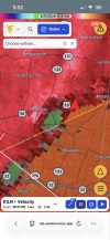
Tornado warned storm in IL has a big hook but looks like outflow slop to me. Apparently it's observed though
akt1985
Member
Is that hail on Ryan Hall’s stream at the University of Illinois?
Kds86z
Member
I am just now catching up . Lots of tornado warnings this afternoon.Monterey, Ohio has some rotation and a radar indicated TOR warning currently
View attachment 54624