
Navigation
Install the app
How to install the app on iOS
Follow along with the video below to see how to install our site as a web app on your home screen.
Note: This feature may not be available in some browsers.
More options
-
Welcome to TalkWeather! We see you lurking around TalkWeather! Take the extra step and join us today to view attachments, see less ads and maybe even join the discussion. CLICK TO JOIN TALKWEATHER
You are using an out of date browser. It may not display this or other websites correctly.
You should upgrade or use an alternative browser.
You should upgrade or use an alternative browser.
Severe WX Severe Threat 25 March 2021
- Thread starter MattPetrulli
- Start date
-
- Tags
- severe wx
Evan
Member
I wonder if their forecast area is too large for current staffing levels? Still, if that's the issue I can't imagine what 6-7 active warnings would've been like in their area...Well surprise surprise, reports of possible tornado damage are coming in from Bartow County, GA with damage to structures and trees. This is where that unwarned couplet with the northern cell was. Good going once again FFC..

Here is a still shot from our new Waynesboro skycam from earlier this evening and what we weren't 100% sure at the time in real time while live on air, but afterwards with a debris signature and intense velocity signature on our live radar and a debris signature also on NEXRAD, damage reports, and seeing power flashes, was the tornado moving into Waynesboro, TN this evening. This is at the 911 center on the west side of town looking back southwest to south as the tornado was moving toward Waynesboro itself. Several reports of not only trees down, lines down, power outages, etc., but also multiple pictures of structural damage of an unknown magnitude. Thankfully, no reports of injuries from what might possibly have been a significant tornado in the area.
Having this skycam alongside our live dual-pol radar in Lawrenceburg really made a huge difference in giving us the confidence to communicate a more serious/urgent tornado threat as the storm was moving into Waynesboro prior to it hitting the town. We wouldn't have been able to do what we did otherwise. So thankful...
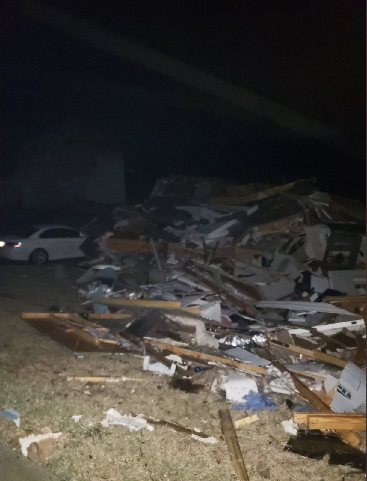
View attachment 7696
That looks like a large, partially rain-wrapped stovepipe tornado to me. Nice capture.Here is a still shot from our new Waynesboro skycam from earlier this evening and what we weren't 100% sure at the time in real time while live on air, but afterwards with a debris signature and intense velocity signature on our live radar and a debris signature also on NEXRAD, damage reports, and seeing power flashes, was the tornado moving into Waynesboro, TN this evening. This is at the 911 center on the west side of town looking back southwest to south as the tornado was moving toward Waynesboro itself. Several reports of not only trees down, lines down, power outages, etc., but also multiple pictures of structural damage of an unknown magnitude. Thankfully, no reports of injuries from what might possibly have been a significant tornado in the area.
Having this skycam alongside our live dual-pol radar in Lawrenceburg really made a huge difference in giving us the confidence to communicate a more serious/urgent tornado threat as the storm was moving into Waynesboro prior to it hitting the town. We wouldn't have been able to do what we did otherwise. So thankful...

CheeselandSkies
Member
Just now catching up on the Georgia stuff that happened while I was asleep. Seems that high-risk days, regardless of whatever else happens, like to produce one of the strongest tornadoes of the event late at night, on the fringes of the risk area (I remember this happening in eastern OK on 5/20/19, fortunately it didn't hit much of anything).
Bama Ravens
Member
Drone footage in Centerville. This is currently live.

 fb.watch
Tornado damage Centerville AL | By Alabama Aerial Photography | Facebook
16K views, 43 likes, 6 loves, 36 comments, 139 shares, Facebook Watch Videos from Alabama Aerial Photography: Tornado damage Centerville AL
fb.watch
TH2002
Member
- Messages
- 4,973
- Reaction score
- 11,113
- Location
- California, United States
- Special Affiliations
- SKYWARN® Volunteer
The video isn't loading for me. Can you embed that?Tornado damage Centerville AL | By Alabama Aerial Photography | Facebook
16K views, 43 likes, 6 loves, 36 comments, 139 shares, Facebook Watch Videos from Alabama Aerial Photography: Tornado damage Centerville AL
Bama Ravens
Member
Well, it’s actually stopped now. I imagine cell coverage is spotty at best down there. It only recorded for a little over a minute.The video isn't loading for me. Can you embed that?
speedbump305
Member
Yesterday was just a horrible day for Alabama georgia and some parts of tennessee. Rest in peace to the 5 people in Otachee alabama who died  i hope everybody in the park of each tornado that touched down was safe and okay!
 ")
i hope everybody in the park of each tornado that touched down was safe and okay! TH2002
Member
- Messages
- 4,973
- Reaction score
- 11,113
- Location
- California, United States
- Special Affiliations
- SKYWARN® Volunteer
Yeah there were multiple reports of cell towers destroyed.Well, it’s actually stopped now. I imagine cell coverage is spotty at best down there. It only recorded for a little over a minute.
Bama Ravens
Member
This is the Alabama Aerial Photography Facebook page. They will surely have a lot of drone video from multiple areas throughout the day.

 www.facebook.com
Alabama Aerial Photography
Alabama Aerial Photography. 73,623 likes · 2,189 talking about this. Film & Photography - Events, Films, Commercial Property, Live Streaming, etc.
www.facebook.com
speedbump305
Member
Yeah there were multiple reports of cell towers destroyed.
Thats not good at all...Yeah there were multiple reports of cell towers destroyed.
TH2002
Member
- Messages
- 4,973
- Reaction score
- 11,113
- Location
- California, United States
- Special Affiliations
- SKYWARN® Volunteer
Newnan, GA


Argus
Member
There are showers redeveloping behind the line. One is about to hit me.
TH2002
Member
- Messages
- 4,973
- Reaction score
- 11,113
- Location
- California, United States
- Special Affiliations
- SKYWARN® Volunteer
Also looks like we're gonna have another round of severe weather this weekend

There hasnt been a lot of tornadoes and when there has they're usually strong long track tornadoes
It really did feel like a "quality over quantity"-type day, that's for sure.
Remember when chasing in the deep south wasn't a thing? Sure is now, and drones are changing the game, as they get the clearest views of typical Dixie torndoes, which are usually haze-covered, tree obscured, low LCL wedges.
Now all we need is for some way to reliably livestream drone footage and we could really change the game for storm chasing/spotting (after all, research has basically shown that when it comes to warning people of tornadoes, the more live footage of tornadoes in action, the better).