
Navigation
Install the app
How to install the app on iOS
Follow along with the video below to see how to install our site as a web app on your home screen.
Note: This feature may not be available in some browsers.
More options
-
Welcome to TalkWeather! We see you lurking around TalkWeather! Take the extra step and join us today to view attachments, see less ads and maybe even join the discussion. CLICK TO JOIN TALKWEATHER
You are using an out of date browser. It may not display this or other websites correctly.
You should upgrade or use an alternative browser.
You should upgrade or use an alternative browser.
Severe WX Severe Threat 25 March 2021
- Thread starter MattPetrulli
- Start date
-
- Tags
- severe wx
WhirlingWx
Member
Mesoscale Discussion 0261
NWS Storm Prediction Center Norman OK
0445 PM CDT Thu Mar 25 2021
Areas affected...central AL
Concerning...Tornado Watch 50...
Valid 252145Z - 252245Z
The severe weather threat for Tornado Watch 50 continues.
SUMMARY...A corridor for a long track intense to potentially violent
tornado is expected to maximize through the next hour across central
AL.
DISCUSSION...An intense tornadic supercell located over Hale County
will likely remain unimpeded as it moves to the east-northeast
across central AL during the next 1-2 hours. The near-storm
environment is currently primed across central AL with 0-1 km SRH at
600 m2/s2 per observed storm motion according to the KBMX VAD.
Given the very moist/strongly sheared environment, expecting a
long-track intense (EF3+) and potentially violent tornado to
continue east-northeast and reach the I-65 corridor over the next
hour or so.
..Smith.. 03/25/2021
Tornado in the Birmingham suburbs.
TornadoFan
Member
Eric Fox on Live Storm Chasing is on some heavy tree damage near Greensboro.
warneagle
Member
Tornado emergency Bibb Co.
TornadoFan
Member
Heads up, Trussville!

warneagle
Member
meteorologist in the area reports the damage path is up to half a mile wide
Sun out in full force in Cullman
CheeselandSkies
Member
TH2002
Member
- Messages
- 4,973
- Reaction score
- 11,113
- Location
- California, United States
- Special Affiliations
- SKYWARN® Volunteer
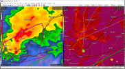
Debris signature ramping back up with the Hale Country tornado

Liberty4dayz
Member

Jeez...
Bama Ravens
Member
Spann has done an extremely rare thing.... roll up his sleeves.
WhirlingWx
Member
Argus
Member
We literally ran back to the office to watch Spann.


warneagle
Member
TDS is moving right up US-11
Keldeo
Member
Jeff Piotrowski heading for the Brent Tornado. This going to be must see here soon