
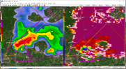
That's probably a large tornado moving into Burnsville.
Navigation
Install the app
How to install the app on iOS
Follow along with the video below to see how to install our site as a web app on your home screen.
Note: This feature may not be available in some browsers.
More options
-
Welcome to TalkWeather! We see you lurking around TalkWeather! Take the extra step and join us today to view attachments, see less ads and maybe even join the discussion. CLICK TO JOIN TALKWEATHER
You are using an out of date browser. It may not display this or other websites correctly.
You should upgrade or use an alternative browser.
You should upgrade or use an alternative browser.
Bamamuscle
Member
Selma storm went near the international paper plant. My pops works out there.. Waiting on him to call me back.
Sent from my iPhone using Tapatalk
Sent from my iPhone using Tapatalk
Kim30
Member
I was asking strictly out of curiosity. I have no travel plans and have a place to seek shelter.Honestly this is where a lot of folks make the mistake of getting too hung up on the wrong thing. I implore you to not consider your plans based off whether or not you are under a high risk technically or a moderate.
CheeselandSkies
Member
- Thread starter
- #986
warneagle
Member
Two likely sigtors already and things haven't even gotten going in the high risk area yet...yikes.
BayouWeatherGeek
Member
Selma storm went near the international paper plant. My pops works out there.. Waiting on him to call me back.
Sent from my iPhone using Tapatalk
I hope he and everyone there are safe
- Thread starter
- #989
warneagle
Member
Brett Adair just tweeted that he's about to get to the Autauga Co. storm.
OHWX97
Member
Several structures likely hit by the Selma storm. That TDS is massive. Substantial amount of debris falling out ahead of it also notable on CC.
Last edited:
- Thread starter
- #991
warneagle
Member
TOR warned now.I'm not liking the look of the circulation south of Brookhaven, MS.
TH2002
Member
- Messages
- 4,974
- Reaction score
- 11,116
- Location
- California, United States
- Special Affiliations
- SKYWARN® Volunteer
Burnsville tornado continuing to show EXTREME signatures on radar. That debris ball is among the worst I've ever seen.
That’s fine, I didn’t mean to pick on you per se either I just wanted to stress to the readers here that there is certainly a high end threat even if you are technically not in the high risk area. Some folks let their guard down if they are in a “lesser” stated threat area and the consequences of that can literally be deadly.I was asking strictly out of curiosity. I have no travel plans and have a place to seek shelter.
Casie
Member
Here the link for all the chasers out today and their feeds.Brett Adair just tweeted that he's about to get to the Autauga Co. storm.
Live Storm Chasing
Watch live feeds as storm chasers try to see if their target verifies. Tornadoes, hurricanes, blizzards, and floods - we've got it all and more, live on our site and available as video on demand.
brianc33710
Member
OK in NE Birmingham rain has slacked off. I dont know the temp though. I guess if the sun reappears that wont matter anyway.
Argus
Member
Looks like a Flood Advisory is out for Birmingham.
Keldeo
Member
Casie
Member
Currently 64/63 in Trussville. Dewpoint up another degree in 30 minutes. Temp staying the same as for now.OK in NE Birmingham rain has slacked off. I dont know the temp though. I guess if the sun reappears that wont matter anyway.