- Thread starter
- #61
akt1985
Member
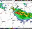
Even the Marginal Risk in southeast Tennessee is trying to overperform today with storms developing west of Chattanooga. NWS Morristown extended the Severe Thunderstorm Watch to west of Chattanooga.
Follow along with the video below to see how to install our site as a web app on your home screen.
Note: This feature may not be available in some browsers.
To add to this threat area, there is also an Extreme Heat Watch for Wednesday for north Florida and South Georgia.I will wait and see tomorrow if it is worth the time to edit the date in the thread as there is a Slight Risk out for Wednesday along the Florida/Georgia border.

BULLETIN - EAS ACTIVATION REQUESTED
Tornado Warning
National Weather Service Peachtree City GA
1029 PM EDT Tue Jul 28 2026
The National Weather Service in Peachtree City has issued a
* Tornado Warning for...
Central Pickens County in north central Georgia...
* Until 1100 PM EDT.
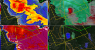
* At 1029 PM EDT, a severe thunderstorm capable of producing a
tornado was located near Sequoyah Lake, or near Jasper, moving
southeast at 15 mph.
HAZARD...Tornado.
SOURCE...Radar indicated rotation.
IMPACT...Flying debris will be dangerous to those caught without
shelter. Mobile homes will be damaged or destroyed.
Damage to roofs, windows, and vehicles will occur. Tree
damage is likely.
* Locations impacted include...
Jasper, Tate, Lake Tamarack, and Marblehill.
PRECAUTIONARY/PREPAREDNESS ACTIONS...
TAKE COVER NOW! Move to a basement or an interior room on the lowest
floor of a sturdy building. Avoid windows. If you are outdoors, in a
mobile home, or in a vehicle, move to the closest substantial shelter
and protect yourself from flying debris.
&&
LAT...LON 3455 8449 3455 8440 3442 8428 3438 8447
TIME...MOT...LOC 0229Z 331DEG 13KT 3453 8443
TORNADO...RADAR INDICATED
MAX HAIL SIZE...<.75 IN


 fox11online.com


Dang sorry, it’s like spring up here in PA. 73 not humid windy, don’t need AC when driving.I would saw a foot off for an Arctic cold front right about now

Y’all have to see this video. This dude got incredibly lucky that he wasn’t seriously injured or killed.