• Welcome to TalkWeather!
    We see you lurking around TalkWeather! Take the extra step and join us today to view attachments, see less ads and maybe even join the discussion.
    CLICK TO JOIN TALKWEATHER

October 12, 2021 Severe weather threat.

TornadoFan

Member
Messages
2,472
Reaction score
2,225
Location
Colorado
There's an enhanced risk out for western Kansas into SW Oklahoma today with a hatched 10 percent risk for tornadoes. A tornado driven upgrade to a moderate risk maybe needed according to the latest outlook.
 

bwalk

Member
Messages
597
Reaction score
291
Location
Prattville, Al
SPC includes a threat of strong tornadoes from southwestern KS into northwestern OK and far northeastern TX Panhandle, mainly this evening just after sunset as low level jet ramps up over 60 knots. (RT) 10/12
 

TornadoFan

Member
Messages
2,472
Reaction score
2,225
Location
Colorado
 

bwalk

Member
Messages
597
Reaction score
291
Location
Prattville, Al
"The Storm Prediction Center is upgrading their severe weather outlook to a level 4 out of 5 "moderate risk."

"One or two powerhouse rotating supercell thunderstorms will form somewhere in the Woodward to Garden City [Ks.] vicinity, and will be nasty – tornadoes/wind/mumbo hail poss.."
(Matthew Cappucci)

(bw: Is "mumbo" hail like the next level up from 'jumbo' hail?? Either a typo or insider jargon I am not familiar with :)
 

TH2002

Member
Sustaining Member
Messages
3,116
Reaction score
4,677
Location
California, United States
Special Affiliations
  1. SKYWARN® Volunteer
Mother Nature has given us EVERY TYPE of weather imaginable across the United States today. Only thing we're missing is the extreme heat (thankfully) but we have plenty of Red Flag Warning areas on top of all the winter weather warnings and advisories, flash flood watches, high wind warnings and now the Tornado Watch.
 
Messages
2,753
Reaction score
4,291
Location
Madison, WI
Surprised at lack of tornado reports given earlier radar appearance of that isolated OK storm, has to be a horde of chasers on it so even if after dark if something happened it would be seen. I wonder if there is some sort of low-level inversion as alluded to by earlier Amarillo AFD, keeping it slightly elevated.
 

Tennie

Member
Messages
935
Reaction score
761
Location
Tennessee
Surprised at lack of tornado reports given earlier radar appearance of that isolated OK storm, has to be a horde of chasers on it so even if after dark if something happened it would be seen. I wonder if there is some sort of low-level inversion as alluded to by earlier Amarillo AFD, keeping it slightly elevated.

Well, the Spotter Network report shapefile that I have loaded into my GRLevel2/3 programs shows a few reports of wall clouds, funnel clouds, and even a brief tornado or two.
 

TH2002

Member
Sustaining Member
Messages
3,116
Reaction score
4,677
Location
California, United States
Special Affiliations
  1. SKYWARN® Volunteer
Still no action in SW Kansas but the storms covering the rest of the first watch have become linear extremely quickly.
 

Tennie

Member
Messages
935
Reaction score
761
Location
Tennessee
TOR right near the KFDR radar!

Capture.PNG

716
WWUS54 KOUN 130041
SVSOUN

Severe Weather Statement
National Weather Service Norman OK
741 PM CDT Tue Oct 12 2021

OKC031-075-141-130130-
/O.CON.KOUN.TO.W.0034.000000T0000Z-211013T0130Z/
Comanche OK-Kiowa OK-Tillman OK-
741 PM CDT Tue Oct 12 2021

...A TORNADO WARNING REMAINS IN EFFECT UNTIL 830 PM CDT FOR WEST
CENTRAL COMANCHE...SOUTH CENTRAL KIOWA AND NORTHWESTERN TILLMAN
COUNTIES...

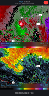
At 741 PM CDT, a confirmed tornado was located near Frederick, moving
northeast at 30 mph.

HAZARD...Damaging tornado.

SOURCE...Weather spotters confirmed tornado.

IMPACT...Flying debris will be dangerous to those caught without
shelter. Mobile homes will be damaged or destroyed. Damage
to roofs, windows, and vehicles will occur. Tree damage is
likely.

Locations impacted include...
Frederick, Snyder, Tipton, Mountain Park, Indiahoma, Manitou, Tom
Steed Reservoir and southwestern Fort Sill.

PRECAUTIONARY/PREPAREDNESS ACTIONS...

To repeat, a tornado is on the ground. TAKE COVER NOW! Move to a
storm shelter, safe room, or an interior room on the lowest floor of
a sturdy building. Avoid windows. If you are outdoors, in a mobile
home, or in a vehicle, move to the closest substantial shelter and
protect yourself from flying debris.

&&

LAT...LON 3459 9911 3459 9908 3461 9909 3462 9908
3464 9910 3468 9908 3467 9906 3469 9904
3470 9905 3470 9907 3480 9904 3467 9870
3426 9902 3434 9920
TIME...MOT...LOC 0041Z 212DEG 25KT 3436 9906

TORNADO...OBSERVED
MAX HAIL SIZE...<.75 IN

$$

BRB
 

TH2002

Member
Sustaining Member
Messages
3,116
Reaction score
4,677
Location
California, United States
Special Affiliations
  1. SKYWARN® Volunteer
Interesting thing is the Frederick storm doesn't even look impressive on Norman's radar. Definitely doesn't scream "PDS TOR" to me which highlights the importance of having weather spotters on the ground.
 

TornadoFan

Member
Messages
2,472
Reaction score
2,225
Location
Colorado
Interesting thing is the Frederick storm doesn't even look impressive on Norman's radar. Definitely doesn't scream "PDS TOR" to me which highlights the importance of having weather spotters on the ground.
You can really see the hook on the Frederick radar.
 
Back
Top