Navigation
Install the app
How to install the app on iOS
Follow along with the video below to see how to install our site as a web app on your home screen.
Note: This feature may not be available in some browsers.
More options
-
Welcome to TalkWeather! We see you lurking around TalkWeather! Take the extra step and join us today to view attachments, see less ads and maybe even join the discussion. CLICK TO JOIN TALKWEATHER
You are using an out of date browser. It may not display this or other websites correctly.
You should upgrade or use an alternative browser.
You should upgrade or use an alternative browser.
Hurricane Melissa
- Thread starter Jacob Aden
- Start date
tornado examiner
Member
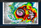
That's weird. Usually a frame like this indicates an ewrc but not this time. Maybe I'm misremembering.I am still trying to wrap my mind around what I just saw. She's just slinging huge thunderstorm complexes around like a hula hoop. What a beast.
View attachment 47837
Cyclonic Paracosm
Member

oooh noo not too sure what this is but wow that looks insane
tornado examiner
Member
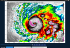
That right there is a solid core that has no signs of any EWRC at all and likely won't for a long time.View attachment 47838
oooh noo not too sure what this is but wow that looks insane
tornado examiner
Member
Kds86z
Member
Kds86z
Member

Cyclonic Paracosm
Member

115kts a 0.5km ouch, massive ouch
TornadoFan
Member
Recon found pressure down to 959mb on the latest pass.
tornado examiner
Member
8MB decrease since 10pmRecon found pressure down to 959mb on the latest pass.
Cyclonic Paracosm
Member
yeah I think its bombing now, wasn't doin that till now if I am not mistaken8MB decrease since 10pm
tornado examiner
Member
Her winds haven’t caught up with her pressure yet. And she’s smiling at us.
With a deviously malicious angry face. You’re f**ked up Melissa.
With a deviously malicious angry face. You’re f**ked up Melissa.
Cyclonic Paracosm
Member

annnd dropsonde time, I can't read these
TornadoFan
Member
115 knots at the surface, that would be 132 MPH.
Ozonelayer
Member
Category 4 then, no?115 knots at the surface, that would be 132 MPH.
TornadoFan
Member
I believe so, yes.Category 4 then, no?
Cyclonic Paracosm
Member
env its moving in is better than Miltons, so yeah its bout to go down
She's currently slinging intense, deep convection around the center of circulation in rapid fashion. Eye is becoming more and more well-defined with time, and there's continuous deep convection firing on the eastern axis of the storm. Continuous rains on the southwestern portions of Hispaniola starting tonight could aggravate mudslides and lead to flooding, which is the last thing Haiti needs. As for Jamaica, the southeastern third of the country is at the start of continuous TS+ force winds and heavy rain for potentially the next 36-48 hours. My biggest concern here is where she turns relative to the island. A significant number of models have her slamming into Jamaica in a fashion that would put Kingston in the front-right quadrant (HAFS-B and HMON included as an example), maximizing winds and storm surge.


tornado examiner
Member
Eye wall is square shaped. Meaning, explosive intensification.