• Welcome to TalkWeather!
    We see you lurking around TalkWeather! Take the extra step and join us today to view attachments, see less ads and maybe even join the discussion.
    CLICK TO JOIN TALKWEATHER

Severe WX March 30th- April 1st 2023 (South, Southeast, Ohio Valley, Upper Midwest)

These three supercells in North Mississippi are very up and down. All have broad low-level mesocyclones. Now, the new TOR has tightened up significantly. I imagine these three will continue this trend into North Alabama.
 
TDS on MS storm...
8f611390122d4b5e8ecc586a9eaa6e54.jpg


Sent from my T767W using Tapatalk
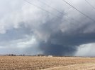
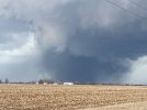
 
So I figured out what happened...I actually caught the cycle on video. When I first got on the storm, set up and started rolling, there was a wedge ongoing. It was shrouded in dust and somewhat low-contrast. It's in these two pictures from my phone.

Those wispy white cloud tendrils toward the near upper left quickly coalesced into a small but tight area of rotation, touching down as a rapidly rotating, dusty debris cloud just behind that treeline, quickly morphing into a Henryville-esque drillbit and then a 4/27-esque (Cordova, Cullman in its later stages, and several others I think) stubby wedge under that dramatically sculpted, ultra-low-LCL tornado cyclone.
 

Attachments

  • PXL_20230331_210850210.jpg
    PXL_20230331_210850210.jpg
    4.9 MB · Views: 0
  • PXL_20230331_210854337.jpg
    PXL_20230331_210854337.jpg
    4.7 MB · Views: 0
Hoping that the TN long-tracker is no longer in progress. Jumbled mess of precip on reflectivity, not much on CC, and a more disorganized look on velocity at the moment. Of course, as soon as that happens, we have a new tornado in NE Mississippi.
 
Back
Top