KevinH
Member
I believe the MOD risk is actually hail driven at 45# tor is 15#A moderate for tornadoes today.
I'm quite surprised
Follow along with the video below to see how to install our site as a web app on your home screen.
Note: This feature may not be available in some browsers.
I believe the MOD risk is actually hail driven at 45# tor is 15#A moderate for tornadoes today.
I'm quite surprised
No, moderate driven tornado. 15% hatched .I believe the MOD risk is actually hail driven at 45# tor is 15#


Like I was kinda yelling about Thursday night. The NAM was onto something when all the others model trends were not so much.
Springtime in Alabama . Make sure if you have students at Auburn to give them a "heads-up" folks
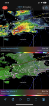
That's right around where the strongest shear is at the moment. Not overly impressive but still 200+ SRH.Storm southwest of Montgomery starting to get that look…
Expecting a ef3 with that. Although it's be crazy if there was another ef4 two days in arow with that tornadoMust have been a fairly stout tornado that went through there.
Expecting a ef3 with that. Although it's be crazy if there was another ef4 two days in arow

Definitely a juicy atmosphere, especially for late March; once the low-level shear starts to increase this could be a problem. The only saving grace is that the shear away from the boundary might not be optimal, otherwise there might be some substantial OWS supercells.
Is the MDT too far south? (ALA speaking)
I think it's good on the tornado threat maybe not the wind or hail.I was just about to post this too