rolltide_130
Member
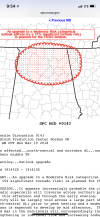
One of the CAM's (The HRW NSSL) does support my line of thought..

Follow along with the video below to see how to install our site as a web app on your home screen.
Note: This feature may not be available in some browsers.
One of the CAM's (The HRW NSSL) does support my line of thought..
That has a line right through Madison Co. hope it’s wrong.
Sent from my iPhone using Tapatalk
One of the CAM's (The HRW NSSL) does support my line of thought..
Specific location of the spike doesn't matter. I'm just showing that it supports the highest threat being near the AL/TN line. That could fluctuate by 30-40 miles in either direction.

Latest HRRR falling in line with my train of thought as well..
I agree, but the start time has been moved up to as early as 12pm for some of the western counties, so I get why they are dismissing early. Whether the main action remains up in the Tennessee Valley remains to be seen.Weather guys in Birmingham are gonna catch heat when the action is up north. Schools are closing at noon or 1 in Blount, Walker, Jefferson counties even though they've been told the action should begin well after 3. Now the models above are showing the main action north of here. Rightly or wrongly, people are going to bash the weather guys down here pretty hard if it looks like a false alarm.
Weather guys in Birmingham are gonna catch heat when the action is up north. Schools are closing at noon or 1 in Blount, Walker, Jefferson counties even though they've been told the action should begin well after 3. Now the models above are showing the main action north of here. Rightly or wrongly, people are going to bash the weather guys down here pretty hard if it looks like a false alarm.
Yeah, I agree. Its not that big of a deal to dismiss early and let parents know in plenty of time (which pretty much everyone did), but the general public is short-sighted, know-it-all, blame casters and social media allows them to broadcast their ignorant outrage to the weather folks. I know one of the meteorologists personally and it has just about driven him into another line of work.I agree, but the start time has been moved up to as early as 12pm for some of the western counties, so I get why they are dismissing early.
The National Weather Service is predicting an increased risk of severe weather for later this afternoon. Until late in the day, the storms will be spotty and dependent on afternoon heating to gain strength. While there is an enhanced risk of damaging winds, large hail and possible tornadoes, most of this threat will come after about 3 pm for the B’ham metro and be primarily north of I-20. Based on NWS models the metro area may see the worst of the threat after 7 pm. All storms this afternoon will be isolated and not everyone will see severe weather. As I said, things don’t seem to get organized into a type of squall line until 8-10 pm. I know K-12 schools are closing early throughout the area, however this is primarily to avoid children in busses on the road during a possible storm. You are encouraged to stay weather aware, know where the safe areas are in your building and make sure you have at least 2 ways of getting weather information. We will continue to monitor conditions and maintain open communication with the National Weather Service.
Also, kids do not get out of school and immediately are at home. Some are on buses for more that an hour. That has to be taken into consideration too. My wife is a teacher and she said if they dismiss at noon, it will be after 1 before the last child is picked up. She can't leave until all the kids are gone. There is a lot to consider in timing the early dismissal.I agree, but the start time has been moved up to as early as 12pm for some of the western counties, so I get why they are dismissing early. Whether the main action remains up in the Tennessee Valley remains to be seen.