• Welcome to TalkWeather!
    We see you lurking around TalkWeather! Take the extra step and join us today to view attachments, see less ads and maybe even join the discussion.
    CLICK TO JOIN TALKWEATHER

Severe WX March 16th-17th, 2023

Taylor Campbell

Moderator
Moderator
PerryW Project Supporter
Messages
2,102
Reaction score
2,189
Location
Wedowee, AL
Special Affiliations
  1. SKYWARN® Volunteer
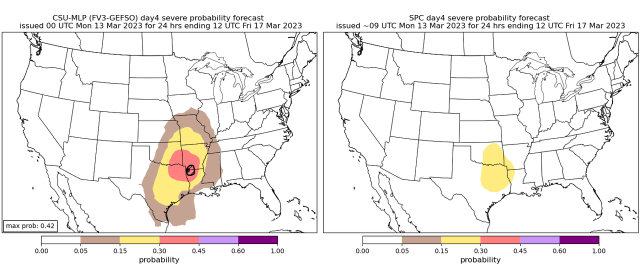
SPC outlined a Day 4 risk area.

EEEDE54B-B124-4004-9723-FD63C99B4A49.png
ACUS48 KWNS 130902
SWOD48
SPC AC 130900

Day 4-8 Convective Outlook
NWS Storm Prediction Center Norman OK
0400 AM CDT Mon Mar 13 2023

Valid 161200Z - 211200Z

...DISCUSSION...
Guidance remains in good agreement that a southern-stream shortwave
trough will eject over the southern Plains on Day 4/Thursday. At
least upper 50s to perhaps mid 60s surface dewpoints should return
northward ahead of this upper trough across parts of central/east
TX/OK into the ArkLaTex vicinity. As mid-level temperatures cool and
daytime heating occurs, weak to moderate instability is forecast to
develop by Thursday afternoon along and ahead of a surface dryline.

Ascent attendant to the shortwave trough should encourage robust
convective development along much of the length of the dryline late
Thursday afternoon and evening. Strong deep-layer shear will easily
support organized convection, including the potential for supercells
with a large hail and damaging wind threat. Additional severe
convection may develop Thursday night across portions of east TX
into the ArkLaTex in a strengthening low-level warm advection
regime. Even though low-level moisture should remain somewhat
limited, enough low-level shear should be present to support some
threat for a few tornadoes as well. Confidence in scattered severe
convection occurring has increased enough to introduce a 15% severe
area for Thursday.

An isolated severe threat may persist into Day 5/Friday across parts
of the central Gulf Coast states as the shortwave trough moves
eastward over the lower/mid MS Valley. However, at this time
confidence remains too low in the quality and northward extent of
appreciable low-level moisture return to include a 15% severe area
for Friday. Some threat for strong to severe thunderstorms could
continue into the upcoming weekend across parts of FL and vicinity,
but predictability remains low at this extended time frame.

..Gleason.. 03/13/2023
 
Last edited:
  • Thread starter
  • Moderator
  • #2

Taylor Campbell

Moderator
Moderator
PerryW Project Supporter
Messages
2,102
Reaction score
2,189
Location
Wedowee, AL
Special Affiliations
  1. SKYWARN® Volunteer
CSU-MLP with a large 30% risk area, max prob over 40% and a hatch contour. Also, the 12z NAM looked bullish on the threat.

974-F534-E-CE94-4-A8-D-B237-1246-AB584-CEB.png
 

JPWX

Member
Messages
1,381
Reaction score
3,595
Location
Smithville MS
The CWASP on the 6z, 12z, and 18z NAM runs all have 90 contours. This is the first time I've seen 3 consecutive runs with a 90 contour. The latest Significant Tornado Ingredients run has a 60 contour already.
 

Attachments

  • CWASPnam212F063.png
    CWASPnam212F063.png
    263.9 KB · Views: 0
  • CWASPnam212F057.png
    CWASPnam212F057.png
    266.5 KB · Views: 0
  • CWASPnam212F051.png
    CWASPnam212F051.png
    268.3 KB · Views: 0
  • SREF_prob_combined_sigtor__f054.gif
    SREF_prob_combined_sigtor__f054.gif
    56.7 KB · Views: 0
  • Thread starter
  • Moderator
  • #9

Taylor Campbell

Moderator
Moderator
PerryW Project Supporter
Messages
2,102
Reaction score
2,189
Location
Wedowee, AL
Special Affiliations
  1. SKYWARN® Volunteer
In proximity to the discrete activity on simulated reflectivity, the HRRR and NAM show a deep effective inflow layer to the 700mb level with significant 90 degree clockwise curvature. The HRRR depicts the point of interest with noticeable updraft helicity streaks into the Piney Woods of East Texas.

CD45C836-74E3-4F80-9853-95CC5E85F608.png
 

JBishopwx

Member
Sustaining Member
Messages
867
Reaction score
1,936
Location
Ackerman, MS
Special Affiliations
  1. SKYWARN® Volunteer
RadarSPC.jpg
THERE IS AN ENHANCED RISK OF SEVERE THUNDERSTORMS ACROSS PARTS OF
NORTH-CENTRAL/NORTHEAST TEXAS...SOUTH-CENTRAL/SOUTHEAST
OKLAHOMA...AND FAR SOUTHWEST ARKANSAS...

...SUMMARY...
Scattered severe thunderstorms capable of producing large hail,
damaging winds, and a few tornadoes appear likely Thursday into
Thursday night across parts of the southern Plains, ArkLaTex, and
lower Mississippi Valley. Some of the hail could be very large over
south-central Oklahoma and north-central Texas.

...Southern Plains into the Lower Mississippi Valley...
A southern-stream shortwave trough will eject eastward from northern
Mexico and the Southwest across the southern Plains and lower MS
Valley on Thursday. A lead low-amplitude shortwave trough is also
forecast to advance quickly northeastward from the southern Plains
to the MS Valley and Midwest through the day. A surface low
initially centered over KS should develop northeastward towards the
mid MS Valley by Thursday afternoon. A secondary surface low should
form over western north TX and shift eastward along/near the Red
River through Thursday evening. A cold front will sweep
southeastward over much of the southern Plains into the lower MS
Valley through the period. A dryline tied to the secondary surface
low will mix eastward across central TX through late Thursday
afternoon.

Low-level moisture characterized by upper 50s to mid 60s surface
dewpoints will continue to stream northward ahead of both the cold
front and dryline. Some guidance suggests that convection may be
ongoing at the start of the period Thursday morning across parts of
TX/OK. This activity will be tied to strong lift/warm advection
associated with a pronounced low-level jet. Even though they should
have a tendency to remain elevated, some of these thunderstorms
could pose an isolated threat for hail/wind through the early
afternoon as the move quickly northeastward. Otherwise, daytime
heating along/near the dryline, but west of any morning convection,
should encourage the development of moderate instability across
parts of north-central/northeast TX and far southern OK. With
steepening lapse rates aloft also expected, MLCAPE of 1500-2500 J/kg
seems probable by late Thursday afternoon across this region.

Initial convective development near the triple point and southward
along the dryline will likely be supercellular given 50+ kt of
effective bulk shear forecast. These supercells will pose a threat
for large hail, some of which could be 2+ inches in diameter.
Somewhat weaker instability farther north in central/eastern OK and
western AR should also support a large hail threat with any
initially discrete development. Convection will grow upscale into an
MCS along the front Thursday evening, with a greater threat for
severe/damaging winds, especially across northeast TX/southeastern
OK and vicinity. There are still some differences in guidance
regarding the strength and placement of a south-southwesterly
low-level jet Thursday evening across east TX into the ArkLaTex and
lower MS Valley. Most guidance, with the 00Z NAM the notable
exception, shows the low-level wind fields gradually
weakening/veering with time along/ahead of the front. Regardless,
ample low-level shear should be present from late Thursday afternoon
through Thursday night to support a threat for a few tornadoes, both
with supercells ahead of the front, and with circulations embedded
within the line.

Additional robust convection should develop across central/
south-central and coastal southeast TX Thursday night into early
Friday morning, with a continued threat for mainly damaging winds
given the linear mode expected. The eastern portion of the MCS will
eventually encounter less instability over the lower MS Valley late
in the period, which should result in a gradually lessening damaging
wind threat with eastern extent.
 

JBishopwx

Member
Sustaining Member
Messages
867
Reaction score
1,936
Location
Ackerman, MS
Special Affiliations
  1. SKYWARN® Volunteer
Today:
RadarSPC.jpg
SPC TOR.jpg

...THERE IS AN ENHANCED RISK OF SEVERE THUNDERSTORMS FOR
NORTH-CENTRAL/NORTHEAST TX...SOUTH-CENTRAL/SOUTHEAST OK...EXTREME
SOUTHWEST AR...

...SUMMARY...
Scattered severe thunderstorms capable of producing large hail,
damaging winds, and a few tornadoes appear likely Thursday afternoon
and evening across parts of the southern Plains. Some of the hail
could be very large over south-central Oklahoma and north-central
Texas.

...Synopsis...
A low-amplitude mid/upper-level shortwave trough will move quickly
from the southern Rockies across the southern Plains today, and into
the mid-MS Valley tonight. Meanwhile, a northern-stream trough will
amplify through the period as a mid/upper-level cyclone moves
southward across Manitoba. The primary surface cyclone will deepen
across the upper Great Lakes region, in response to the
northern-stream system. A strong cold front will surge southeastward
across much of the Great Plains and Midwest, reaching deep south TX
and the lower MS Valley by Friday morning.

...Southern Plains...
The environment will become quite favorable for organized severe
storms across the parts of the southern Plains into the ArkLaTex
this afternoon into tonight. Low-level moisture will stream
northward through the day, south of the surging cold front and
along/east of a weak surface trough that may effectively become a
weak dryline due to differential heating/mixing. Diurnal heating
will promote moderate to locally strong destabilization (MLCAPE of
1500-2500 J/kg) across the warm sector, in the presence of
relatively steep midlevel lapse rates. Effective shear will increase
into the 40-60 kt range as strong midlevel flow overspreads the
region.

Despite the favorable environment, some aspects of the synoptic
pattern may mitigate the threat of long-lived supercells, at least
to some extent. The primary southern-stream shortwave will emerge
rather early in the day, moving across OK in the 18-21Z time frame
and quickly moving away from the warm sector by 00Z. The low-level
jet will remain relatively veered through the day and become focused
into parts of the mid MS Valley and Midwest, in response to the
deepening cyclone over the Great Lakes. The fast-moving cold front
may tend to quickly undercut any discrete cells that develop across
the warm sector. These factors cast some uncertainty on the coverage
and duration of supercell development this afternoon and evening,
though scattered severe thunderstorms potentially capable of
producing all severe hazards are still expected this afternoon and
evening.

Surface-based storms may develop along the front as soon as 18Z
across central OK into western north TX, as the main shortwave
trough ejects eastward. Meanwhile, isolated to widely scattered
discrete storm development will be possible later this afternoon
from south-central OK into north-central TX along the pre-frontal
trough/weak dryline.

The initial frontal storms and any discrete development across the
warm sector may quickly evolve into supercells across south-central
OK and north-central TX, with a threat of very large hail and
isolated severe gusts. Also, despite somewhat veered low-level flow,
effective SRH of 200-400 m2/s2 (larger with eastward extent) will
support a tornado threat (including a conditional risk for a strong
tornado) with any sustained supercells that can avoid being undercut
by the front. Higher tornado probabilities may eventually be needed
if multiple long-lived pre-frontal supercells appear increasingly
likely.

The potential for pre-frontal storm development is more uncertain
with southwestward extent across south-central TX, with this area
being further removed from the ejecting shortwave trough. However,
any discrete supercell development along the pre-frontal trough or
the front itself would quickly pose a threat of large hail and
isolated severe gusts. Storm coverage will increase with time along
the front tonight. While there will be a tendency for storms to be
undercut by the front in this area, the strongest updrafts may still
be accompanied by hail and isolated strong gusts.

...ArkLaTex region into the lower MS Valley...
A supercell or two may develop out of initially elevated convection
across the ArkLaTex region later today. While this scenario remains
very uncertain, low-level shear/SRH will be sufficient for a tornado
or two, should any convection become surface-based in this area
during the afternoon or early evening. Later tonight, extensive
frontal convection will spread into the region, with low-level and
deep-layer shear remaining sufficient for a threat of damaging gusts
and a couple of tornadoes, especially where any embedded supercells
or bowing segments can be maintained without being undercut by the
front. A weakening trend is expected late tonight as storms move
into a less unstable environment, but some threat for locally
damaging wind and possibly a brief tornado may extend as far as the
lower MS Valley by 12Z Friday morning.
 

Attachments

  • SPC TOR.jpg
    SPC TOR.jpg
    495 KB · Views: 0

JBishopwx

Member
Sustaining Member
Messages
867
Reaction score
1,936
Location
Ackerman, MS
Special Affiliations
  1. SKYWARN® Volunteer
FRIDAY:
RadarSPC2.jpg

...THERE IS A SLIGHT RISK OF SEVERE THUNDERSTORMS ACROSS PARTS OF
THE CENTRAL GULF COAST STATES...

...SUMMARY...
Isolated to scattered severe thunderstorms may occur Friday across
parts of the central Gulf Coast states. Damaging winds should be the
main threat, but a tornado or two also appears possible.

...Central Gulf Coast States...
A large-scale upper trough centered over the Upper Midwest and MS
Valley will translate slowly eastward on Friday. An embedded,
low-amplitude shortwave trough will shift quickly northeastward
across the OH Valley, Mid-Atlantic, and Northeast through the day.
The primary surface low initially centered over the Great Lakes is
likewise forecast to develop northeastward into Canada by Friday
evening. An attendant cold front will advance quickly
east-southeastward across the Southeast through the period.

An expansive line of thunderstorms will likely be ongoing along or
just ahead of the cold front Friday morning from parts of LA into MS
and northern AL. The intensity of thunderstorms along/near the front
will probably tend to remain fairly muted Friday morning owing to
weak boundary-layer instability and gradually decreasing low-level
convergence along the front. This may lead to updrafts being
undercut by the cold front. Still, an isolated threat for
strong/gusty winds producing occasional damage should persist as
convection spreads east-southeastward during the morning.

A moist low-level airmass characterized by upper 50s to mid 60s
surface dewpoints should return northward ahead of the front across
portions of LA/MS/AL/FL and GA. While mid-level lapse rates are
expected to remain generally poor, daytime heating of this moist
airmass should encourage weak instability to develop through Friday
afternoon. MLCAPE generally ranging from 500-1000 J/kg seems
probable, with greater instability forecast closer to the Gulf
Coast.

A gradual uptick in thunderstorm coverage and intensity should occur
Friday afternoon, with 40-50+ kt of deep-layer shear supporting
convective organization. A mainly linear mode is expected, with
isolated to scattered damaging winds the main threat. Enhanced
low-level flow is forecast to slowly weaken/veer through the day as
the main forcing for ascent shifts northward and away from the
Southeast. Still, sufficient low-level shear should remain to
support some threat for a tornado or two with circulations embedded
within the line. Thunderstorms should eventually weaken Friday
evening/night across GA and north FL as they outpace the low-level
moisture return.
 
  • Thread starter
  • Moderator
  • #19

Taylor Campbell

Moderator
Moderator
PerryW Project Supporter
Messages
2,102
Reaction score
2,189
Location
Wedowee, AL
Special Affiliations
  1. SKYWARN® Volunteer
The 12z nadocast introduced 10% hatch tornado probs. Yesterday, the HREF/GFES calibrated hazard guidance showed 10%. HREF-STP 24hr calibrated shows 15%. This area is pinged hard for tornado potential around Dallas.

D272CE66-2736-4EF1-8C6B-6AC4AE44735C.png
 
Logo 468x120
Back
Top