• Welcome to TalkWeather!
    We see you lurking around TalkWeather! Take the extra step and join us today to view attachments, see less ads and maybe even join the discussion.
    CLICK TO JOIN TALKWEATHER

January 23-25th Winter Wx

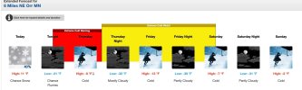
Point and click forecast for NE Minnesota is showing showing a -39F forecast low. I cannot remember I saw something that low on a NWS forecast in the lower 48.

Considering that most NWS point and click forecasts are generally conservative (with respect to temperature extremes), I would not be shocked to some isolated temps below -50F on Saturday morning. Incredible cold, approaching all time record low for the state.
 

Attachments

  • Image 1-21-26 at 10.01 AM.jpeg
    Image 1-21-26 at 10.01 AM.jpeg
    133.8 KB · Views: 0
12Z GFS continues the northern trend of the ice line in central Alabama, but CAD puts GA further in the icebox. A fairly awful look for the ATL metro and east.
View attachment 50079
Yeah, not feeling as great as y'all across Alabama about all this. CAD, which often saves us during severe events, may give us a lot of trouble here.
 
Remember that models can underestimate the strength of the CAD. This could lead to even higher Ice Accumulations.

Any word on Hurricane Hunters who flew into the low?
Nope, I think there flight is around 2-3 pm if I'm not mistaken.

*Well look at the post below there was one yesterday, I thought it was today at 2-3 pm lol
 
I'll be honest, I'm not feeling confident about any of this forecast. The more it sets up vertical as it passes, the more I wonder about the strength of the eventual low and where it tracks. It evolving into off the eastern seaboard after it passes us has my attention - that's a complex and fast evolution, and an error on that track of 100 miles would mean significant forecast deviations. Same with the strength - we have a warmer than usual for this time of year gulf, and one heck of a boundary setup coming. The potential for low pressure mischief is there as well, even with these air masses as large as they are.

I am so glad I am not a meteorologist responsible for a forecast right now, this one would have me a total wreck.

Me, personally - I'm hoping I get to store a propane heater unopened in the box. :D
 
Yeah, the truth of the situation is if you're adequately prepared and supplied, this storm will be a ton of fun for the vast majority of people. Losing all the food in your fridge and freezer due to an extended power outage will suck a lot of the fun out of it, but it's certainly not the apocalypse lots of people are making it out to be.
I agree, but the reality is a lot of people don't prepare, and some are unable to. With wind chills potentially dropping into the single digits, the cold could be a danger of its own.
 
GFS ensembles are really moving in the direction of the big warm nose and more vertical system. The gulf says "I win". (At least for now - beware the windshield wiper effect, we may swing back to cold yet. Not so far though.)
1769013486746.png
 
Kind of ironic. As the Euro trends further North, it takes a lot of you out of the ice. Which is a good thing of course, but that northern shift wants to put that ice storm right on top of Tennessee and southern KY.

At this point, I’d love that warm air nose to keep its as$ pinned to the gulf so we all just get snow instead haha.
 
i look forward to the euro dropping mid 80s on central AL tonight. give it a few hours and we’ll have gone from an icy grave to a tropical paradise on january 24th

reed timmer massive wedge tornado *slight* hyperbole loading.
 
with the QPFs so high, one thing i feel sure about is we are going to see some absolutely epic pictures and video of all types of winter precip. sleet falling so hard it is deafeningly loud and piling up a foot high? sure. a crippling freezing rain event where someone gets 2 inches of ice? likely. someone buried under 2 feet of snow? probably so.

and of course the disappointed weather weenies in birmingham looking at wet roads
 
Back
Top